




SETENA D6 Form for Projects in Urban Blocks
The D6 is a specific environmental impact assessment procedure for certain residential, commercial and service activities located in officially recognized urban blocks.
The D6 applies to certain projects located within recognized urban blocks
Being surrounded by a city or located in a built-up area is not enough. This procedure requires proof that the site officially forms part of an urban block and that the proposed activity falls within the scope established for D6.
Residential, commercial or service project
The proposed activity must be one of the types covered by Article 24 to use this environmental assessment procedure.
Location within an urban block
The property and the Project Area must be within a location officially recognized as an urban block under the applicable procedures.
Documentary evidence
The application must include documentation formally demonstrating urban-block status to SETENA.
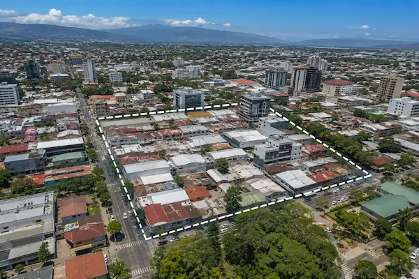
What does it mean for a property to be within an urban block?
An urban block refers to an urban area within a population center where roads, buildings, infrastructure and services are concentrated. Its boundaries must be established by planning instruments or competent authorities.
Established urban fabric
These are areas associated with population centers where infrastructure, services and urban activities are concentrated.
Visual appearance is not sufficient
A property that appears urban in aerial imagery is not, by itself, proven to be part of a recognized urban block for D6 purposes.
Location determines the procedure
The official boundary must be compared with the registered property and Project Area to determine whether D6 is applicable.
The application must prove that the project is actually within an urban block
The supporting source depends on the land-use planning arrangements in each municipality. We therefore begin by reviewing which instrument or authority defines the relevant urban block.
Urban-block status must be supported by evidence in the application
SETENA's guidelines require documentary evidence that the proposed activity, works or project will take place within an urban block.
For that reason, we do not recommend choosing D6 simply because the property is in a densely built-up area. We first verify the applicable official boundary.
SETENA needs to understand how the project will be laid out on the property
For construction projects, the proposal must be related to the land through area measurements, building footprint, impervious cover, green spaces and earthworks.
The D6 may require technical studies or a professional justification for not submitting them
Being in an urban setting does not eliminate the need to understand subsurface conditions, hydrogeology or the possible presence of archaeological heritage.
Geotechnical Study
Characterizes ground conditions relevant to foundations and the project's geotechnical behavior. Where technically appropriate, the regulations allow a professional justification for not submitting the study.
Rapid Archaeological Report
Provides an initial assessment of archaeological conditions within the Project Area. Where technically appropriate, the professional justification allowed for not submitting the study may be provided.
Hydrogeology Protocol
The D6 includes a hydrogeological component to assess project conditions, including the relationship with wells, springs and watercourses where applicable. Non-submission must also be technically justified by a qualified professional in the relevant discipline.
The Project Area must be represented correctly in the mapping
The Digital Platform uses geospatial data to locate the project. This geometry must match the property, site design and areas used in the various technical studies.
Project Area
We map the area where the activity, works or project will take place.
Linear features
We prepare the linear geometry required by the Digital Platform to represent the project.
Site location
We include the corresponding project reference point in the geospatial dataset.
Mapping consistent with the official coordinate system
Current guidelines require geospatial files to be georeferenced in CRTM05 or whichever official projection system is legally in force.
What information must be included in a D6 application?
The application brings together developer, property and project information, urban planning, mapping, technical studies and environmental measures.
We confirm the urban-block procedure and integrate the D6 technical components
Our first task is to confirm that the project can actually follow the D6 procedure. Once established, we coordinate the territorial, environmental and technical information needed to build a consistent application.
From urban boundary verification to the environmental decision
We locate the property
We review ownership records, the cadastral plan and the project location.
We confirm urban-block status
We identify the official source and obtain the relevant supporting evidence.
We characterize the project
We integrate the design, areas, earthworks and Project Area conditions.
We prepare studies
We prepare or coordinate the relevant studies and professional justifications.
We compile the D6 application
We enter the information, mapping, measures and documents in the Digital Platform.
SETENA issues a decision
The authority reviews the application and issues the corresponding administrative decision.
The D6 includes follow-up during environmental management
Once Environmental Viability is granted, oversight may include an environmental manager, Environmental Responsibility Reports and records in the Digital Environmental Logbook, according to the conditions established by SETENA.
Environmental assessment of projects in urban blocks before SETENA
The D6 forms part of the Environmental Impact Assessment system regulated by Executive Decree No. 43898.
National Environmental Technical Secretariat
SETENA
The D6 does not replace other project permits
SETENA assesses the environmental aspects of the activity, works or project within the scope of D6 and issues the administrative Environmental Viability decision.
Urban planning, building, sanitary, utility and any other required authorizations remain within the jurisdiction of the relevant institutions.
Executive Decree No. 43898-MINAE-S-MOPT-MAG-MEIC
The D6 Urban Block procedure is regulated principally by Articles 24–27 and Annex 7 of the Environmental Assessment, Control and Monitoring Regulation.
SETENA D6 and urban blocks
Can every project located within a city use D6?
No. The activity must fall within the scope of D6, and the Project Area must be inside a recognized urban block under the procedures set out in the regulations.
How do I prove that my property is within an urban block?
The applicable official source must be identified, such as a Local Regulatory Plan, INVU boundaries, regional planning instruments or municipal documents, as appropriate.
Does D6 still apply to telecommunications towers?
No. Under the current Regulation, telecommunications towers use the D1-Torres procedure. The current D6 applies to activities, works and projects located in urban blocks.
Must I always submit geotechnical, archaeological and hydrogeological studies?
The D6 addresses these technical components, but in certain cases the regulations allow a professional justification for not submitting one or more studies.
Does D6 replace the municipal building permit?
No. SETENA Environmental Viability and urban planning or building permits are separate procedures administered by authorities with different responsibilities.
What do you need to begin reviewing my project?
Useful starting documents include the cadastral plan, property location, project description, approximate area, preliminary site design and any available municipal or urban planning documents.
Is your project in an urban area, and do you need to know whether D6 applies?
We can review the location, urban planning, project type and available documents to confirm the appropriate environmental procedure before preparing the application.
Let's review the location first
Send us the cadastral plan, property location, a brief project description and any available land-use certificates, municipal documents or relevant background information.