



Hydrogeological Study
At Geo Costa Rica, we conduct hydrogeological studies to understand how groundwater is stored and moves, characterize aquifer conditions, and examine their relationship with wells, springs, water intakes and development projects.
Interpreting how groundwater behaves beneath a site
A hydrogeological study integrates geological, hydrological and water-source data to understand the conditions governing groundwater storage and movement.
How is groundwater stored, and where does it flow?
Understanding groundwater involves more than locating a well. Aquifer behavior depends on geology, material permeability, groundwater levels, topography and connections between different parts of the system.
The study organizes this evidence to develop a coherent interpretation of hydrogeological conditions within the area of interest.
The scope varies from project to project. It depends on the hydrogeological question, site conditions and available information.
Understanding groundwater requires connecting geology, water levels and flow
We analyze evidence to understand where groundwater is stored, how it may move and how the aquifer relates to water intakes and its surroundings.
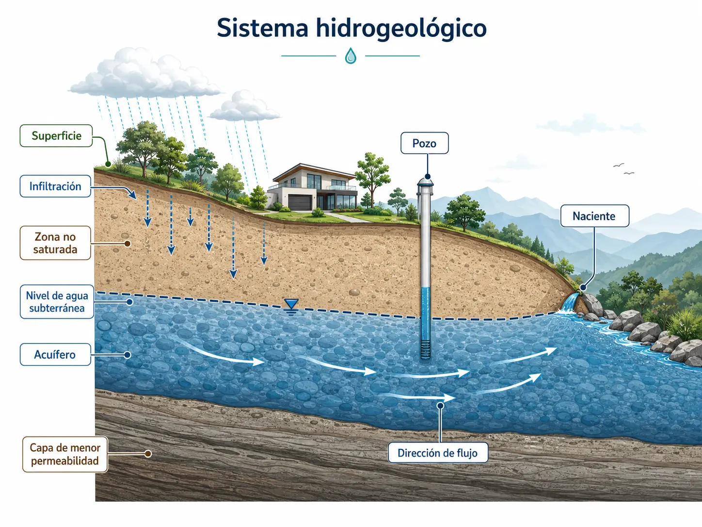
Materials that store or transmit groundwater
We examine geological units, relative permeability, contacts, fractures and other conditions that may influence aquifer behavior.
Spatial distribution of groundwater
Observed levels in wells and water intakes help establish groundwater position and, where sufficient information is available, analyze its spatial distribution.
Wells and springs as sources of information
Well depths, groundwater levels, lithological logs and other records from existing water intakes provide direct evidence from different parts of the system.
How water may move through the aquifer
We integrate water levels, topography and hydrogeological conditions to interpret the general groundwater flow direction when the available evidence allows.
From existing information to a conceptual hydrogeological model
Our interpretation brings together existing information, field observations and hydrogeological data relevant to the project question.
Review
Geology, topography, mapping, wells, springs, previous studies and other available information.
Field verification
We check relevant site conditions and assess the reliability of existing records.
Integrate
We connect geological units, groundwater levels, water intakes, terrain and other available evidence.
Interpret
We develop a conceptual model describing the overall functioning of the groundwater system.
Not every hydrogeological study requires the same methods
Depending on the objective, investigations may use groundwater-level measurements, well records, hydraulic tests, geophysical surveys, boreholes or other techniques. These methods are included when needed to answer the hydrogeological question.
Turning well and groundwater-level data into a system-level interpretation
The findings integrate available evidence to represent key hydrogeological units and understand groundwater distribution and movement.
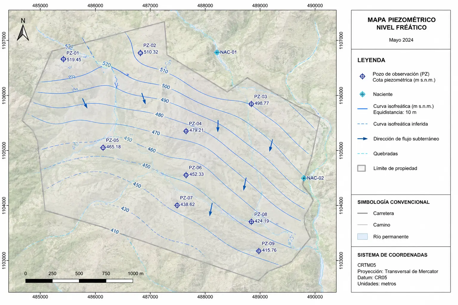
An integrated representation of the aquifer
The final content depends on study scale, the amount and quality of available data, and the specific investigation objective.
A well reveals conditions at one point; a hydrogeological model explains the system
Data from a water intake become more meaningful when considered alongside other wells, geology, terrain and groundwater levels. This integration makes it possible to interpret the aquifer beyond a single observation point.
When is a hydrogeological study useful?
A hydrogeological study is particularly valuable when the groundwater system must be understood before investigating a more specific issue.
Once the system is understood, specific questions can be examined in greater depth
Common questions about hydrogeological studies
What does a hydrogeological study include?
The scope depends on the technical question and available information. It may integrate geology, groundwater levels, wells, springs, mapping and additional investigations needed to understand the system.
Is it the same as a pumping test?
No. A hydrogeological study aims to understand the overall aquifer system. A pumping test assesses the hydraulic response of a well or water intake during groundwater extraction.
Are boreholes or geophysical surveys always necessary?
No. They are used when existing information is insufficient to answer the hydrogeological question or when further investigation is needed.
Can a hydrogeological study support a permitting procedure?
Yes. Certain institutional procedures may require hydrogeological information. The applicable scope and requirements depend on the procedure, responsible authority and case-specific conditions.
View the permits and procedures we handleUnderstand the aquifer beneath your project
Geo Costa Rica conducts hydrogeological studies to characterize aquifers, interpret groundwater levels and flow, and connect this information with wells, springs, water intakes and development projects throughout Costa Rica.