



Water Use Concessions before the Water Directorate
Geo Costa Rica manages water use concession applications before the MINAE Water Directorate in Costa Rica, for both groundwater and surface water. We can also coordinate the technical studies required to assess the source, available flow and the project's actual water needs.
What is a water use concession?
A water use concession is an authorization through which the MINAE Water Directorate establishes the conditions for legally using a particular water source in Costa Rica.
Where the water comes from
The application must identify the groundwater or surface water source intended for use.
Why the water is needed
The proposed use must be linked to the needs and activities justifying the application.
How much water is requested
The requested flow rate must be supported by the characteristics of the source, demand and applicable technical information.
A concession is required when a project intends to use water from a regulated source
This need may arise when developing a new project, using a well, drawing water from a spring, abstracting water from a river or stream, or incorporating an existing source into the supply system of an activity.
Well
A drilling permit does not, by itself, establish a permanent right to use the water obtained.
Spring
Using a spring requires consideration of source availability, requested flow rate and intended use.
River or stream
The application must account for the specific conditions of the watercourse and proposed abstraction.
New demand
Residential, tourism, agricultural, commercial or industrial activities may require their own water supply source.
A concession may involve groundwater or surface water
A well, spring and surface watercourse are not assessed in the same way. The water's origin determines the technical information to collect and the most suitable application approach.
Wells
For a new well, the concession is closely linked to the drilling permit, construction results, pumping test and any applicable hydrogeological studies.
View Well Drilling PermitsSprings, rivers and streams
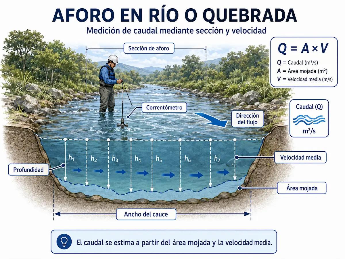
The assessment may require direct measurements of source flow, variability, abstraction point conditions and the relationship to project demand.
View Surface Water SourcesHaving a water source is not enough: we need to match the available supply with the project's actual needs
A water use concession application should be based on a technically sound relationship between source availability, its behavior, actual project needs and the requested flow rate.
Source
We identify where the water will come from.
Availability
We assess what is known about the source's capacity, continuity and behavior.
Demand
We determine how much water the planned activity or development actually needs.
Application
We relate the technical information to the flow rate requested under the concession.
How much water can the source provide?
Depending on the source, the answer may require flow measurements, pumping tests, hydrogeological interpretation, background records or other technical assessments.
How much water does the project need?
Water demand depends on the project's use, scale, occupancy, production, irrigation or commercial, tourism, industrial or agricultural activity.
A spring, river or stream may vary considerably between the rainy and dry seasons
Direct measurement of a source establishes its flow under the observed conditions. Where seasonal variability is significant, it is also important to understand how the source may behave during less favorable periods.
Measuring during lower-flow conditions can provide especially useful information
A measurement taken only during very wet conditions may reflect high availability rather than the source's behavior throughout the year.
Where variability is significant, dry-season measurements can help characterize less favorable conditions. Depending on the study objective, comparing measurements taken on different dates may be advisable.
Not all concessions require the same technical studies
The supporting information depends on the source type, requested flow rate, existing records, location, intended use and specific application conditions.
Source and Demand Assessment
Relates the known or investigated capacity of a water source to the project's actual requirements.
View Source and Demand AssessmentRiver and Spring Flow Measurements
Measures the flow of a spring, river or stream directly under specified conditions.
View River and Spring Flow MeasurementsPumping Test
Assesses the hydraulic response of a groundwater abstraction point under controlled pumping.
View Pumping TestHydrogeological Study
Interprets aquifer units, flow, water levels, wells and relevant hydrogeological conditions.
View Hydrogeological StudyWater Balance
Can be used to analyze inflows, outflows, storage and water resource behavior within a defined system.
View Water BalanceMapping and Spatial Analysis
Connects the source, properties, abstraction points, infrastructure and other spatial components of the project.
View Mapping and Spatial AnalysisHow do we manage a new water use concession?
The exact procedure varies according to the source and project conditions, but the technical work can be organized into a logical sequence.
Need
We define why water is required.
Source
We identify the well, spring or surface water source.
Background
We review existing records and the current status of water use.
Availability
We determine what needs to be known about the source.
Demand
We substantiate the project's water requirements.
Studies
We prepare the applicable technical assessments.
Application
We prepare and submit the application to the Water Directorate.
Admissibility
We address any applicable requests for clarification or corrections.
Follow-up
We support subsequent stages of the administrative process.
Technical assessment
Relevant information and procedural steps are incorporated into the file.
Decision
The Water Directorate decides on the application.
Water use
The conditions ultimately authorized must be followed.
For a new well, drilling and concession procedures are part of the same pathway
A new well application incorporates the drilling permit and related concession procedures from the beginning. However, obtaining an exploratory drilling permit does not, by itself, establish the right to use the water.
Permit
Exploratory drilling is authorized.
Drilling
The actual construction characteristics of the well become known.
Pumping
The well's hydraulic response is evaluated.
Studies
Any additional required technical assessments are submitted.
Concession
The conditions for water use are determined.
SETENA environmental approval may also be part of the concession process
Water use concessions are administered by the MINAE Water Directorate. Environmental assessment is a separate procedure, but both should remain technically coordinated when required.
Proposed water use
We define the intended source, its location and the flow rate the project needs.
Environmental approval
Environmental documentation must be consistent with the source and proposed water use forming part of the project.
Concession
The Water Directorate verifies the relevant environmental status under the applicable procedure.
Geo Costa Rica combines application management with the studies needed to substantiate it
We can start with the project's water requirements and guide the client through source assessment, technical studies, mapping, application preparation and follow-up with the Water Directorate.
Have you received a request for corrections or additional information from the Water Directorate?
We can review the request, identify what the institution needs and coordinate the technical or documentary response within the agreed scope of services.
Clarifications
Review and supplementation of submitted information.
Corrections
Documentary, mapping or technical adjustments.
Additional studies
Further investigations where genuinely needed.
Follow-up
Incorporating the response into the administrative file.
A property with a well, spring or abstraction point is not necessarily ready to supply your project
When water availability affects a property purchase, the technical and administrative status of the source should be reviewed before assuming it can be used under the same conditions in the future.
If a concession already exists, you may not need to file a new application
An existing concession may require renewal, transfer, a change of use, an adjustment to the authorized flow rate, updated records or other procedures depending on its circumstances.
Renewal
When the authorized term ends and water use is to continue under the applicable conditions.
Change of holder or transfer
Purchasing the property should not be interpreted as automatically transferring the concession's registered holder.
Change of conditions
A new use, altered flow rate, changed location or other modifications may require a specific procedure.
Do several property owners or users share the same water source?
For collective water use, it may be necessary to assess how the users, properties, shared infrastructure and concession should be organized.
A specific legal arrangement for certain collective water uses
The Water Directorate recognizes Water Users' Associations (Sociedades de Usuarios de Agua) for collective use of water from public-domain sources.
Where this arrangement applies, the association must first be established and registered, followed by the concession application for collective water use.
Water use concessions in Costa Rica
What is a water use concession?
A water use concession establishes the conditions under which a specific water source may be used legally in Costa Rica.
Who grants water use concessions in Costa Rica?
The competent authority for deciding on water use concessions is the MINAE Water Directorate.
Does Geo Costa Rica handle water concession applications before the Water Directorate?
Yes. Geo Costa Rica can manage a concession application before the Water Directorate and coordinate the technical studies required for the source and proposed use.
Who can help me apply for a water concession?
Geo Costa Rica provides technical consultancy and application management, integrating water resources, hydrogeology, mapping and institutional follow-up.
Do I need a concession to use water from a well?
Yes. Groundwater use is subject to a concession. A drilling permit does not replace the authorization to use the water resource.
Can I use the water immediately after drilling a well?
Not automatically. After drilling, the technical documentation, pumping test, applicable studies and required procedural stages must be completed so that the Water Directorate can decide on the conditions of water use.
Can I request a concession to use water from a spring?
Yes. A spring may be covered by a water concession application, subject to assessment of the technical and administrative conditions applicable to the case.
Can I request a concession to use water from a river or stream?
Yes. The Water Directorate provides for concessions involving surface water sources such as rivers and streams. The supporting studies must reflect the source's and project's characteristics.
How do I determine the flow rate I can request?
The requested flow rate must be related to source availability and the project's actual demand. Depending on the case, flow measurements, pumping tests or other technical studies may be necessary.
Why might it be important to measure a spring or stream in the dry season?
Because a measurement taken during very wet conditions can reflect a period of high water availability. A dry-season measurement can provide useful information on source behavior under less favorable conditions.
What studies do I need to apply for a concession?
There is no single package of studies applicable to every concession. The scope depends on source type, flow rate, intended use, location, existing information and specific application conditions.
How long does a water concession take?
A single timeframe would be misleading. The procedure may involve admissibility review, corrections, publication, hearings, technical assessment, inspections and other steps depending on the file.
My concession is about to expire. Do I need to apply for a new one?
Not necessarily. The Water Directorate has a specific process to extend the term when the applicable conditions of water use remain unchanged.
I bought a property and the concession is still in the previous owner's name. What should I do?
Buying the property does not automatically change the concession holder. The administrative file should be reviewed and the relevant transfer or update requested.
I need more water than is currently authorized. Must I request a new concession?
Not necessarily. Changing the authorized flow rate may require a specific procedure and additional technical support depending on the source and circumstances.
I already have a concession, but the project's water use has changed. What is required?
A change in activity or use may require modifying the conditions of an existing concession. The current authorization and the project's new requirements should be reviewed first.
The next step depends on the water source and current authorization status
I want to develop a new well
The process begins by assessing drilling requirements and the groundwater procedure.
Drilling PermitI have a spring, river or stream
First, the source, its flow rate and its ability to meet project demand need to be understood.
Surface Water SourcesThere is already a well or concession
Start by reviewing existing records, ownership and authorized conditions.
Existing Wells and Water UsesI need another water-related procedure
The Water Directorate manages other procedures involving wells, watercourses, discharges and water uses.
View Water DirectorateDo you need to use a water source but are unsure which studies or permits are required?
We can start by reviewing the source, location, water demand and existing records to identify the most suitable approach to the Water Directorate procedure.
Send us the information you already have
You do not need to know every requirement or the exact name of the technical study in advance.
- Property location
- Source type: well, spring, river or stream
- Intended water use
- Estimated flow or consumption, if known
- Existing files, concessions or studies