



Groundwater Flow Tube and Capture Zone Study
At Geo Costa Rica, we prepare flow tube and capture zone studies to identify the portion of an aquifer supplying water to a well or spring and analyze its relationship with properties, projects, and potential contamination sources.
Identify the portion of the aquifer supplying water to the intake
The capture zone is the area of an aquifer from which groundwater ultimately reaches a well or spring. A flow tube represents this relationship through groundwater flow paths converging toward the intake.
Which part of the aquifer actually supplies a well or spring?
This study helps establish the hydraulic origin of water reaching an intake. Its value goes beyond delineating an area: it helps interpret which parts of the land or aquifer are directly connected to the water source.
In practical terms, it helps identify activities located hydraulically upgradient that may be relevant to water quality and intake protection.
A capture zone is not usually circular: its shape depends on groundwater flow
The shape and extent of a flow tube depend on the regional flow direction, aquifer piezometric conditions, and characteristics of the intake.
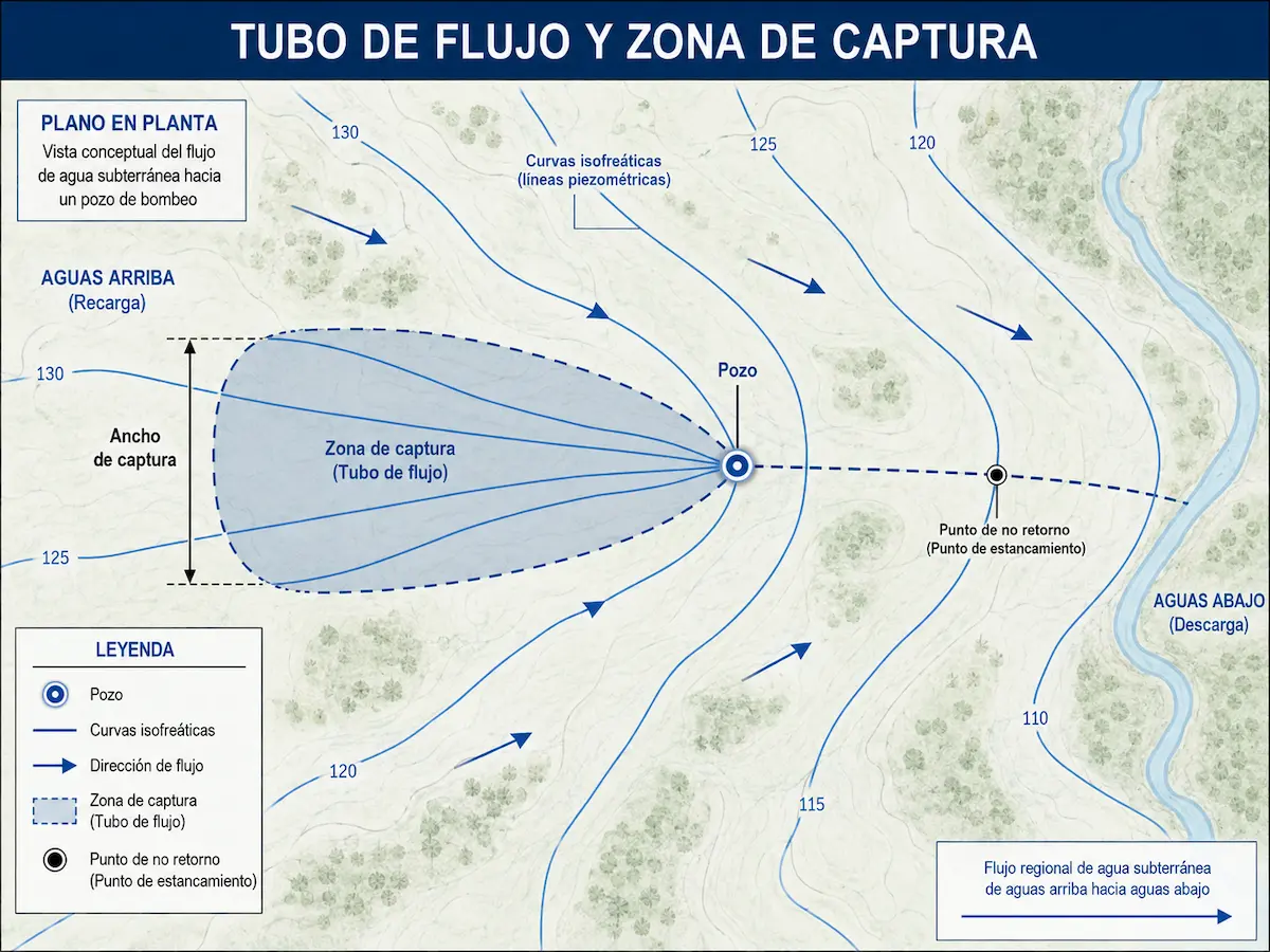
Water does not reach a well equally from every direction or location
In an aquifer, groundwater flow direction determines the area from which water may be captured. Capture zones therefore commonly extend farther upgradient and narrow toward the intake.
- General direction of groundwater flow.
- Groundwater contour lines or available piezometric information.
- Approximate width of the capture zone.
- Stagnation point, where applicable.
- Relationship between the well and the regional flow pattern.
This analysis replaces a generic idea of protection with a more precise hydraulic interpretation of where the water supplying the source actually comes from.
The study applies to both wells and springs
Although the general principles are the same, the interpretation differs for a pumped intake and a natural discharge such as a spring.
Intakes associated with pumping or extraction
For a well, the capture zone is related to the aquifer's regional flow and the intake's operating conditions. This helps identify the portion of the aquifer directly contributing water to the well.
Natural discharge from a hydrogeological system
For a spring, the analysis identifies the area where groundwater flow converges and naturally discharges at the source. This is important for understanding its protection needs and relationship with the surroundings.
Understanding where water comes from helps interpret risks, land uses, and project interactions
Capture zone analysis can help assess whether a property, activity, or planned development lies inside or outside the area contributing water to an intake.
A capture zone map tailored to the intake and project
The purpose is not only to explain groundwater flow but to turn that information into useful technical and cartographic evidence for decision-making.
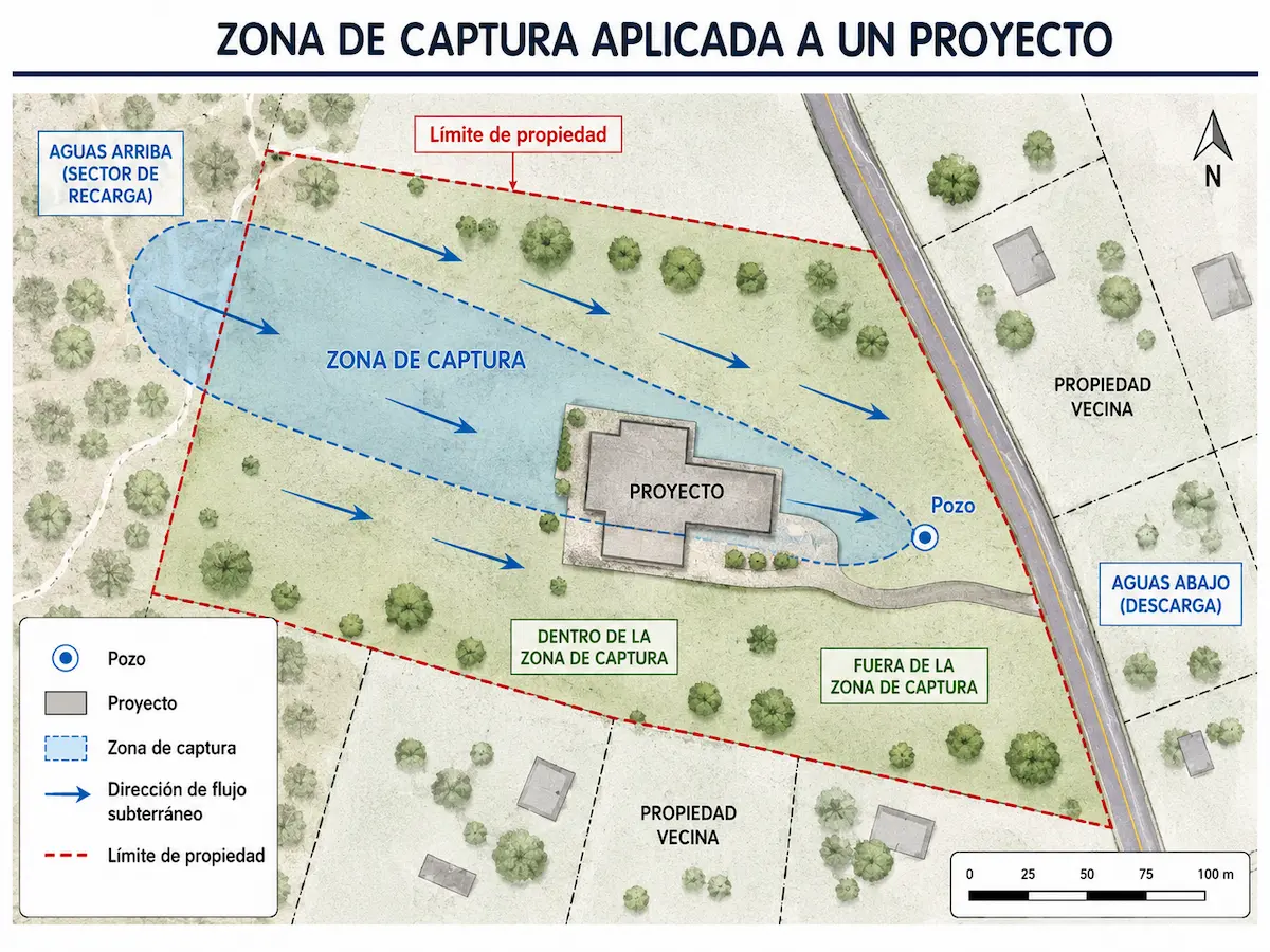
Intake, aquifer, groundwater flow, and territorial context
Key variables
- Location and characteristics of the intake.
- Water levels and groundwater flow direction.
- Available hydrogeological parameters of the aquifer.
- Relationship with properties, projects, and land uses.
- Conditions relevant to interpreting hydraulic capture.
Technical input for protection and planning
- An interpretive capture zone map or diagram.
- Technical interpretation of where the water originates.
- Relationship between the intake and the assessed land.
- Identification of hydrogeologically sensitive areas.
- A technical basis for complementary studies, when appropriate.
When is a Groundwater Flow Tube and Capture Zone Study useful?
This report can be particularly valuable when the relationship between an intake, groundwater flow, and a property, activity, or project needs to be understood.
Wells and springs
When the contributing portion of an aquifer needs to be identified to better understand the hydrogeological protection of an intake.
Relationship between property and intake
When assessing whether a project lies inside or outside the area supplying water to a well or spring.
Understanding groundwater flow
When a hydrogeological study must go beyond general flow direction toward an applied interpretation of hydraulic capture.
Support for protection and management
The assessment can complement protection zone delineation, contaminant transport studies, ROP assessments, or other hydrogeological analyses, depending on the project's objectives.
Common questions about flow tubes and capture zones
What is a capture zone?
It is the area of an aquifer from which groundwater ultimately supplies a well or spring.
Are a flow tube and a capture zone the same thing?
They are part of the same analysis. The capture zone identifies the contributing area, while the flow tube conceptually represents the convergence of groundwater toward the intake.
Is this the same as a protection zone?
No. A capture zone helps explain where the water originates. A protection zone also incorporates safeguards against contamination and other water-source protection objectives.
Can this be used to assess the relationship between a project and a well?
Yes. One important application is to determine whether a property or project lies within the portion of an aquifer contributing water to an intake.
Request a Groundwater Flow Tube and Capture Zone Study
At Geo Costa Rica, we prepare studies to interpret the capture zones of wells and springs and their relationship with projects, properties, and local hydrogeological conditions.