



Hydrological Study
We analyze how rainfall becomes runoff and streamflow within a watershed or drainage area to provide useful information for development projects, drainage systems, hydraulic structures and environmental assessments.
A hydrological study estimates how a watershed responds to rainfall
Its purpose is to understand how much water a watershed or drainage area may generate and which flow rates should be considered for a project, discharge, stormwater structure or specific technical assessment.
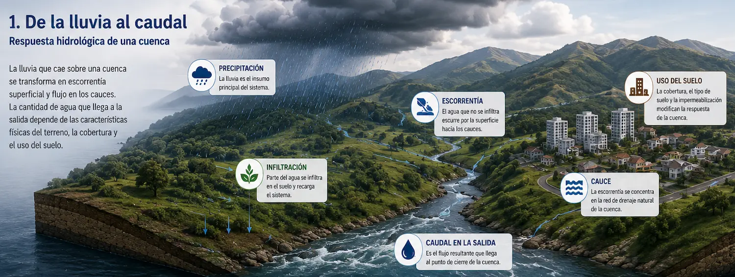
From rainfall on the land to flow at the outlet
In practical terms, a hydrological study examines the relationship among precipitation, infiltration, runoff, the drainage network and streamflow.
Not every rainfall event produces the same response. Watershed behavior depends on physical characteristics, soils, slopes, land cover and land use.
At Geo Costa Rica, we integrate this information to produce results useful for design, planning, environmental assessment and water resource management, tailoring the analysis to the scale and purpose of the project.
Hydrology determines how much flow a watershed may generate; hydraulic analysis subsequently examines how that flow behaves within a channel or structure.
The same rainfall does not produce the same flow on every site
Hydrological response depends on watershed characteristics, land cover and the extent to which conditions favor infiltration or surface runoff.
Watershed characteristics
Area, shape, flow path length, terrain, slopes and the drainage network affect how quickly water concentrates toward the outlet.
Soils and land cover
Soil type, vegetation and land cover influence infiltration, surface retention and generated runoff.
Land use
Urban development, pavement, roofs and impervious surfaces reduce infiltration and often result in a faster response and higher peak flow.
Therefore, natural land and an urban development do not necessarily generate the same runoff, even under similar rainfall. This difference is particularly important for drainage design, outfalls and stormwater management.
From rainfall records to design flow
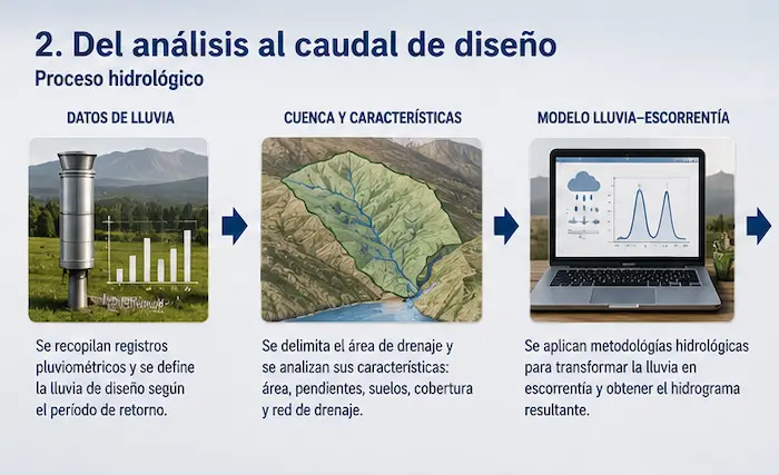
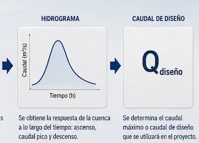
The exact scope depends on the project, but a hydrological study generally integrates rainfall data, watershed delineation, site characterization and technical analysis to estimate the expected response.
1. Data collection
We gather precipitation data, maps, terrain models, land cover, drainage information and other relevant data for the study area.
2. Delineation and characterization
We define the watershed or drainage area, analyze its physical characteristics, and examine existing site conditions and, where applicable, the proposed development.
3. Hydrological modeling
We apply appropriate hydrological methods to transform rainfall into runoff and obtain parameters, hydrographs and flows relevant to the study objectives.
A project can change the site's hydrological response
In many cases, assessing the site's natural condition is not enough. It is also necessary to analyze how hydrological behavior changes when land is urbanized or otherwise transformed.
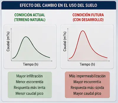
Existing conditions
Land with more natural cover generally favors infiltration, delays flow concentration and produces a slower response.
Future conditions
Adding roads, roofs, parking areas and other impervious surfaces may increase runoff and peak flow.
Why it matters
This comparison can be essential to justify stormwater management, detention, outfall, conveyance or runoff-control measures.
Useful information for project decisions, drainage and technical assessment
Final deliverables depend on the requested scope, but the report generally provides specific inputs for design, planning and assessment of infrastructure or developments.
What can it deliver?
- Watershed or drainage-area delineation.
- Physical and hydrological characterization.
- Analysis parameters and design criteria.
- Hydrographs and flow estimates.
- Estimates of peak flow appropriate to the scope and methodology of the study.
- Comparison of changes in hydrological response associated with the project.
- Technical documentation and professional interpretation.
When might it be needed?
- Stormwater drainage design or review.
- Discharges and outfalls to a receiving water body.
- Residential subdivisions, condominiums and property developments.
- Infrastructure works such as culverts and bridges.
- Support for environmental or engineering studies.
- Basis for subsequent hydraulic analysis.
At Geo Costa Rica, we prepare the Hydrological Study with a clear, technical approach focused on the project's actual needs, avoiding generic or unnecessarily complex reports.
Hydrology protocol for projects submitted to SETENA
Depending on project characteristics and its relationship with the local sub-watershed, an environmental assessment file may require hydrological information to evaluate the land's response to precipitation and changes associated with the proposed development.

Sub-watershed hydrology and project response
The study characterizes the hydrological response of the project area and examines how runoff and flow rates may change as a result of planned site modifications.
The scope is defined according to the project's location, size, land cover, proposed impervious surfaces, drainage and other relevant characteristics.
What can the study assess?
Not every hydrological question is answered by the same report
A hydrological study may be supplemented by other technical reports depending on the project's questions and the required level of detail.
Stream and Spring Flow Measurement
Measures flows observed in the field. It may complement a hydrological study but does not replace it.
View studyFlood Hazard Assessment
Evaluates potential spatial impacts of flooding. It uses hydrological inputs but addresses a different question.
View studyHydraulic Study
Examines how flow behaves within a channel, canal, culvert, bridge or other structure. It is complementary but distinct.
Discuss this caseFrequently asked questions about hydrological studies
Is this the same as a hydraulic study?
No. A hydrological study estimates watershed response and flow rates; a hydraulic study examines how that flow behaves within a channel or structure.
Is this the same as a flood hazard assessment?
No. Flood hazard assessment examines potential effects on an area, while hydrological studies focus on rainfall, runoff and hydrographs.
Is the same methodology always used?
Not necessarily. The methodology depends on the purpose of the study, scale, available information and the question that needs to be answered.
Does a flow measurement replace a hydrological study?
Not necessarily. A flow measurement provides a point measurement or observed time series, whereas a hydrological study also considers watershed response to rainfall.
Can SETENA require a Hydrological Study for a D1 submission?
Yes, depending on the characteristics of the application. The applicable procedure includes a Hydrology Protocol and calls for the relevant study or a technical justification when it does not apply.
Do you need a Hydrological Study for your project?
At Geo Costa Rica, we prepare hydrological studies to understand watershed or drainage-area response, estimate flow rates and provide useful information for project design, planning and assessment.
We can review your project's characteristics and define the necessary level of analysis based on its purpose, available information and the type of infrastructure or development.