



Delineation of protection zones for wells and springs
We delineate areas hydrogeologically connected to a water source by analyzing the aquifer, groundwater flow direction, hydraulic properties and pumping response, providing a technical basis for groundwater protection.
Protecting a water source means understanding where the water reaching the well comes from
A well does not draw water only from its immediate surroundings. Groundwater moves through the aquifer under conditions governed by geology, water levels, hydraulic properties and pumping. Understanding these relationships helps identify which areas may be most important for protecting the water source.
A well draws water from a system extending beyond its location
The well's position is only the point where water is withdrawn. To understand how to protect it, we must also analyze the aquifer that supplies it and the conditions under which water moves toward the well.
Water moves along a direction and hydraulic gradient
Water levels observed at different locations help interpret the general direction of groundwater flow and identify areas hydraulically connected to the well.
Aquifer properties govern how water moves
Material type, permeability, saturated thickness, fracturing and other hydrogeological characteristics can affect the speed, direction and distribution of flow within the system.
Withdrawal can locally modify groundwater flow
When a well is pumped, it produces a hydraulic response around the withdrawal point. The pumping rate and aquifer properties influence how that response develops across the system.
Protection-zone geometry should reflect how the hydrogeological system operates
A uniform distance around the well describes proximity, but does not necessarily represent the direction of groundwater movement or how pumping interacts with the aquifer.
Where sufficient hydrogeological information is available, we can analyze flow, hydraulic properties and well response to develop a delineation that better reflects the actual conditions of the system under study.
How close a location is to the well
Distance describes spatial proximity but does not, by itself, establish a meaningful hydrogeological connection with the water source.
Where the pumping response may occur
Hydraulic influence describes the aquifer's response to withdrawal and provides important information, but is not necessarily equivalent to a protection zone.
Which areas matter for preserving water quality at the source
Protection-zone delineation integrates hydrogeological information to identify areas whose relationship with the well should be considered in groundwater management and protection.
Radius of influence and protection zone do not mean the same thing. The former relates to the hydraulic response caused by pumping; a protection zone seeks to identify hydrogeologically relevant areas for safeguarding the water source. Both concepts may use common information, but address different technical questions.
We analyze the system that governs groundwater movement toward the well
Delineation requires relating well information to aquifer conditions. We examine geology, water levels, flow direction, hydraulic properties, pumping and other factors to understand which areas are hydrogeologically connected to the water source.
Materials and units forming the aquifer system
We review geological units, materials, structures and subsurface conditions that may govern groundwater storage and movement around the well.
Establish a reference for piezometric conditions
Levels observed in wells and other monitoring locations allow us to compare hydraulic conditions and interpret the distribution of hydraulic head across the study area.
Interpret groundwater direction and gradient
The distribution of water levels makes it possible to estimate general flow direction and hydraulic gradient, essential information for identifying where water may move toward the well from.
Understand the aquifer's ability to transmit water
Where suitable data exist, we incorporate hydraulic parameters that help represent water transmission within the aquifer and the system's response to pumping.
Relate water withdrawal to aquifer response
We consider well location, depth, construction and pumping rate, along with available information about hydraulic behavior and operating conditions.
Include nearby wells, activities and site conditions
Other water sources, possible recharge areas, land uses and potential sources of impact help us interpret the zone in its hydrogeological and territorial context.
Before delineating a zone, we need to understand how the system works
Delineation does not begin by drawing a shape. We first interpret the aquifer units, water levels, flow direction and the well's relationship with the system.
This conceptual model allows us to select parameters and analysis methods appropriate to the available information and the specific protection objective.
Available information on the aquifer and wells
Well records, lithological logs, water levels, hydrogeological studies and other available sources provide a starting interpretation and reveal data gaps.
Measurements that help verify the interpretation
Water levels, pumping data, hydraulic tests and other field observations can provide direct evidence to better characterize system behavior.
Relate hydrogeology to the surrounding area
The location of wells, potential sources, properties, land uses and other spatial features can be incorporated to understand conditions within and around the area under study.
The quality of a delineation depends on the quality of its underlying hydrogeological model. Better information on geology, water levels, flow, hydraulic properties and well behavior improves our ability to represent hydrogeologically connected areas in a technically consistent way.
We delineate zones according to how the hydrogeological system supplying the well operates
We start with a conceptual aquifer model and available information on flow, hydraulic properties and pumping. We then select an analytical method suited to the system and spatially represent areas meaningfully connected to the water source.
We develop the hydrogeological model
We integrate geology, water levels, water sources, flow direction and other available background information to understand how the aquifer system containing the well works.
We define parameters and select the analytical method
We review pumping rate, hydraulic properties, gradient, aquifer geometry and data quality to choose a procedure consistent with actual system conditions.
We delineate and interpret protection areas
We apply the selected method, map the results and compare them with flow direction, well location and surrounding features before establishing the final delineation.
The resulting geometry must be consistent with the supporting data
A mathematical result requires hydrogeological interpretation. We review the delineation against flow direction, geology, well characteristics and the scale of the available information.
We also consider model limitations and avoid implying greater precision than the data support. Where significant gaps remain, further measurements or studies may be required to delineate the zone with greater confidence.
The zone may extend preferentially toward certain areas
The distribution of hydraulic head helps interpret the direction from which water travels toward the well and guides the spatial delineation.
The pumping rate is part of the hydraulic relationship
Well withdrawal conditions influence how the system responds and may change the extent of areas connected to the source.
Water-transmission capacity influences the result
Hydraulic properties, aquifer thickness and other characteristics affect the shape and extent of the resulting delineation.
Different protection objectives may involve different scales
Depending on the study objective, delineation may examine different spatial or temporal relationships between groundwater and the well.
The level of detail depends on data quality
More hydrogeological observations can support a more specific interpretation, while limited information requires us to acknowledge greater uncertainty.
Delineation relates to real features of the landscape
Once the zone is delineated, we can compare it with properties, activities, infrastructure and potential sources of impact to better understand conditions within the protection area.
A protection zone is the result of a hydrogeological model, not an absolute boundary of the aquifer. Its precision and confidence depend on available information, assumptions inherent in the method and how well the model represents actual system conditions.
Delineation becomes useful when we relate it to the surrounding area
The study spatially represents areas hydrogeologically connected to a water source and examines what lies within them. Interpretation combines the resulting geometry with properties, land uses, activities, infrastructure and potential sources of impact.
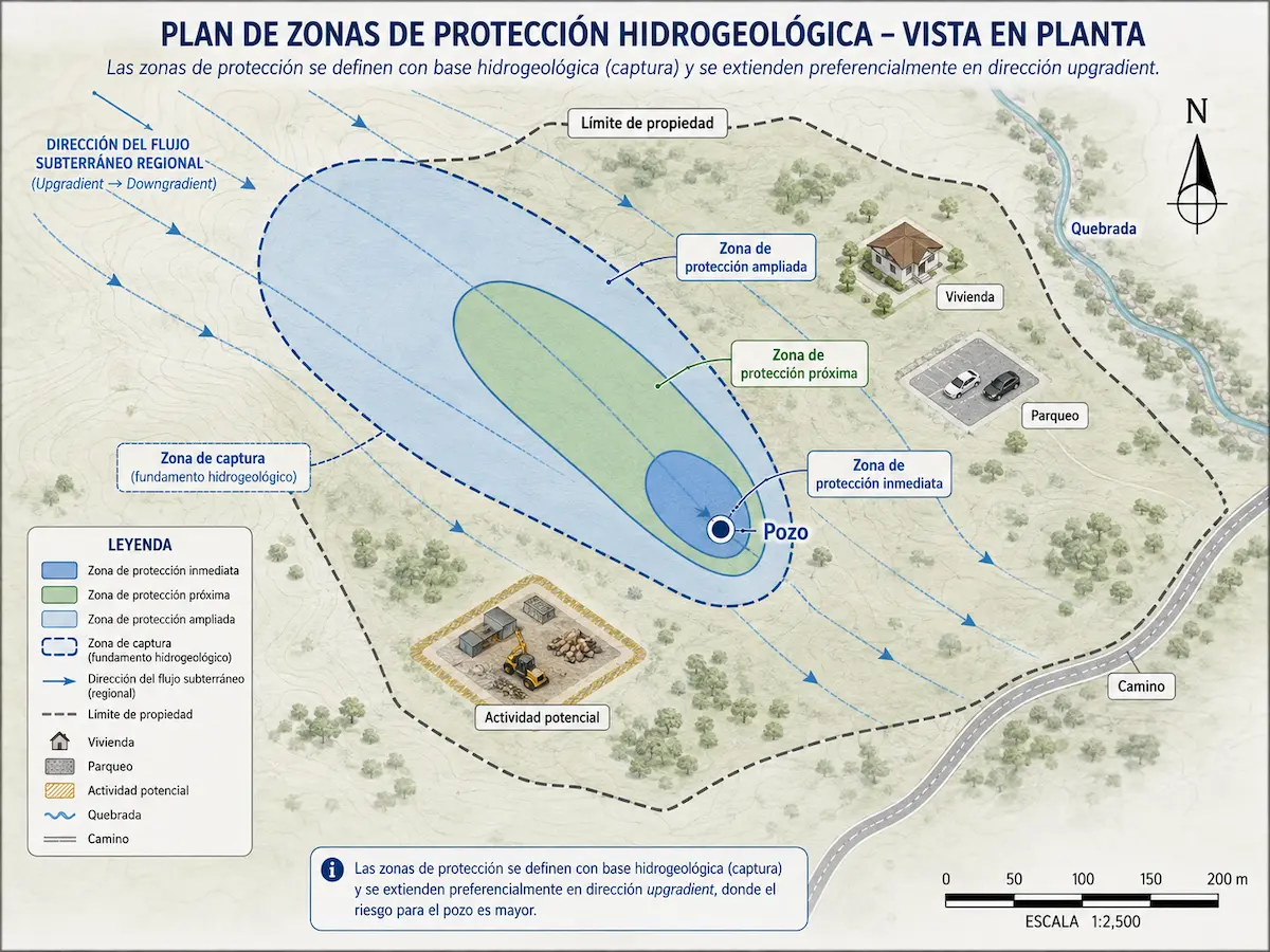
A protection zone shows which areas warrant closer consideration
The delineation can be mapped alongside properties, roads, infrastructure, wells, water bodies and other features to show how it relates to the area where a project is planned.
Depending on the method and study objective, areas with different levels of importance for water source protection may be distinguished.
The key question is what happens within the delineated zone
Once the areas connected to the well have been mapped, we can examine the land uses, activities and features that overlap them and identify those requiring closer hydrogeological assessment.
This interpretation turns a purely geometric result into a useful tool for informing source protection, planning and management decisions.
A protection zone indicates hydrogeological relevance, not contamination
An activity within the zone does not automatically imply an adverse impact. Its significance must be assessed in light of the activity's characteristics, potential contaminant sources and hydrogeological connection to the well.
Confidence in the delineation also depends on data quality, methodological assumptions and the available understanding of the aquifer.
Being within a protection zone does not automatically mean contamination or impact exists. Delineation identifies hydrogeologically relevant areas; activities within them must be assessed according to their characteristics and actual connection with the groundwater system.
A protection zone can provide a basis for assessing and managing the area surrounding a water source
Once areas hydrogeologically connected to a well have been delineated, they can be used to examine activities, identify potential sources of impact and determine whether a project needs additional studies of aquifer vulnerability, contaminant transport or groundwater behavior.
Recognize important areas around a well
Delineation helps show which areas are hydrogeologically connected to the well and deserve closer attention in the surrounding area.
Review land uses within the zone
We can compare the delineation with land uses, infrastructure, disposal systems, chemical storage and other activities that may require specific evaluation.
Assess locations before developing an activity
When new works or activities are planned around a well, the protection zone can inform comparisons between alternatives and reveal areas requiring further assessment.
Identify where more detailed analysis is warranted
A potential source within the zone may justify a more focused investigation of its connection to the subsurface, groundwater flow paths and the water source.
Integrate well protection with geographic information
The delineation can be incorporated into maps and geographic databases to analyze properties, activities, infrastructure and other relevant features in the protection area.
Reassess changes that may affect local conditions
New activities, changes in water withdrawal or additional hydrogeological data may call for reassessing the interpretation and updating the delineation used to manage the well.
Aquifer Protection
Provides an integrated assessment of the water resources that require protection, surrounding pressures and technical studies that may be needed to guide groundwater management.
Ask about this serviceAquifer Vulnerability Assessment
Characterizes how susceptible an aquifer may be to contaminant infiltration and provides context for interpreting natural conditions within a protection zone.
Ask about this studyContaminant Transport Assessment
Where a particular source exists, this study examines the potential movement of a substance from its origin toward a well or part of the aquifer of interest.
Ask about this studyA protection zone may require information from other investigations
When existing information is insufficient, it may be necessary to better characterize the aquifer or obtain additional hydraulic data before delineating the zone with greater confidence.
A hydrogeological study can strengthen the conceptual model, while a pumping test may provide information on the system's hydraulic response and parameters useful for certain analysis methods.
A protection zone does not replace aquifer vulnerability or contaminant transport studies. Delineation identifies areas connected to a water source; complementary studies can examine aquifer susceptibility or the relationship between a specific source and groundwater in more detail.
Do you need to delineate a protection zone around a well or spring?
We can review available well information, aquifer conditions and the protection objective to determine which data are missing, which delineation method is appropriate and what level of analysis the existing knowledge can support.