



Operational Protection Radius (ROP) Reduction Study
Geo Costa Rica prepares hydrogeological studies to assess whether the Operational Protection Radius (ROP) around a well can be reduced without compromising the protection of the water intake or the aquifer.
An immediate protection area surrounding the well
The ROP is the prescribed setback around a well intended to protect the water intake and reduce the likelihood that nearby activities could affect groundwater quality.
Can a shorter setback be used without compromising well protection?
In certain cases, the prescribed setback around a well may constrain property use or project design. The regulatory framework allows a shorter distance to be technically assessed when justified by hydrogeological conditions.
The study must demonstrate that activities proposed within the requested setback are compatible with protecting both the aquifer and the well itself.
When the ROP Constrains Property Use or Project Design
An existing well may impose significant constraints on buildings, infrastructure, parking areas, treatment systems or other project components.
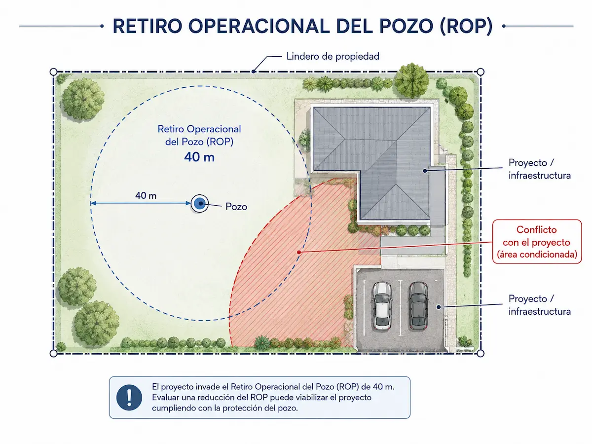
The well remains in place, but what can be developed around it?
This conflict may arise during the design of new construction, expansion of existing infrastructure or environmental assessment of a property with an existing well.
A spatial conflict does not mean that the ROP can be automatically reduced. Adequate protection of the well under the proposed conditions must first be demonstrated through technical assessment.
We Assess More Than a Distance: We Assess Effective Well Protection
The study examines the relationship between well characteristics, aquifer behavior and proposed activities around the well.
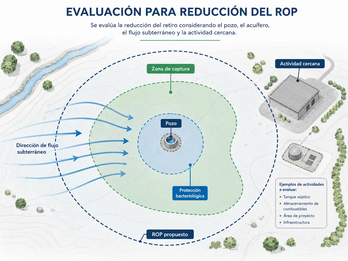
Well, Aquifer, Activity and Protection
Supplementary Investigations May Inform the Study
Depending on site conditions, the assessment may draw on aquifer vulnerability, contaminant transport, capture zones, bacteriological protection, hydraulic tests or other available hydrogeological information.
A Proposed Setback Supported by Site-Specific Evidence
The report brings together the information needed to determine whether a request to reduce the ROP has a technical basis and under what conditions it could be proposed.
Well and Aquifer Conditions
- Technical information on the well.
- Geological and hydrogeological setting.
- General groundwater flow direction.
- Vulnerability and protection conditions.
- Relevant available technical records.
Assessment of the Requested Setback
- Identification of activities proposed within the ROP.
- Assessment of potential threats to the well.
- Hydrogeological justification for the proposed setback.
- Maps or site plans illustrating the assessed conditions.
- Conclusions and protection measures, where applicable.
Geo Costa Rica Prepares the Study; Approval Rests with the Competent Authority
The report provides the technical basis for requesting a reduction of the Operational Protection Radius. Acceptance of the proposed distance and any applicable conditions depends on review by the Dirección de Agua (Water Directorate).
When Might You Need an ROP Reduction Study?
This study is particularly useful when the existing setback around a well constrains a project or the use of a property.
The Assessment May Draw on Other Hydrogeological Studies
Common Questions About ROP Reduction
What Does ROP Mean?
ROP stands for Retiro Operacional del Pozo (Operational Protection Radius). It is the immediate area around a well intended to safeguard its operation and reduce the risk of damage or contamination.
Can the ROP Always Be Reduced?
No. Feasibility depends on the aquifer, well conditions, proposed nearby activities and whether the study can demonstrate adequate protection on technical grounds.
Are the ROP and the Radius of Influence the Same?
No. The radius of influence describes the hydraulic extent of drawdown caused by pumping. The ROP is a setback intended to protect the well from nearby activities.
Does the Study Guarantee Approval by the Water Directorate?
No. Geo Costa Rica prepares the supporting technical study and can assist with the application, but the competent authority makes the final decision on the reduction.
Assess the Feasibility of an ROP Reduction
Geo Costa Rica prepares Operational Protection Radius Reduction Studies that integrate well characteristics, aquifer conditions and activities proposed around the well.