



Hydrogeological Vulnerability Reassessment
Geo Costa Rica conducts local hydrogeological studies to assess whether the existing vulnerability classification adequately represents the actual conditions of a property. The study provides a technical basis for the corresponding institutional review by SENARA.
What does hydrogeological vulnerability reassessment mean?
It means investigating a property at a local scale to determine whether its actual hydrogeological conditions agree with the area's existing vulnerability classification.
Regional vulnerability maps are essential tools for groundwater planning and protection, but their scale may not capture all the geological and hydrogeological details within an individual property.
When there is a technical reason to review these conditions, a more detailed local hydrogeological investigationmay be undertaken.
The objective is not simply to seek a “change in vulnerability classification”, but to establish through technical evidence which hydrogeological conditions actually characterize the site.
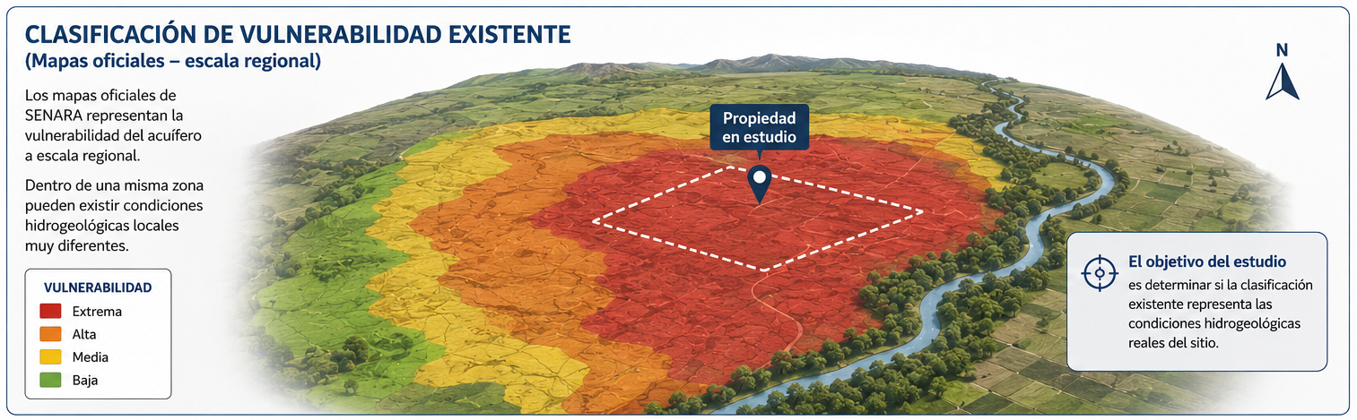
A regional map and an individual property are not assessed at the same scale
A reassessment uses local evidence to determine whether the regional model adequately describes the conditions within the property under investigation.
A regional classification is developed from the information available across a broad area. Within that area, local variations in geological materials, thicknesses, groundwater depths and other hydrogeological factors may occur.
For this reason, a technically substantiated reassessment requires investigating the site and developing a local hydrogeological model, rather than simply changing the category displayed on a map.
When might reassessment be appropriate?
There must be a technical reason to investigate the site's hydrogeological conditions in greater detail.
When the available map is regional
A regional classification may not capture geological or hydrogeological variations within a particular property.
When local data can improve the site assessment
Wells, groundwater levels, outcrops, boreholes, geophysics and other evidence can support a more detailed local interpretation.
When vulnerability affects a land-use decision
A technical review may be necessary where the classification influences the assessment or feasibility of an activity, construction project or development.
Not every unfavorable classification justifies reassessment. Before starting an investigation, it is advisable to review available mapping, background studies and known site conditions to establish whether further analysis is technically justified.
How is vulnerability investigated at a local scale?
The scope depends on site conditions and the information available. The investigation must generate sufficient evidence to develop a defensible hydrogeological interpretation.
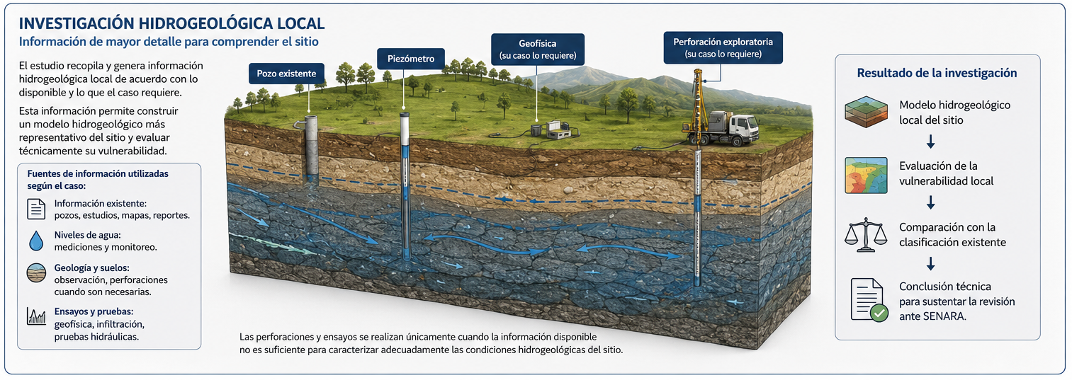
The investigation may combine background studies, mapping, geological reconnaissance, well and spring records, field measurements, and direct or indirect exploration methods.
- Geology and subsurface materials.
- Depth and behavior of the water table.
- Characteristics of aquifer units.
- Thickness and properties of the unsaturated zone.
- Nearby wells, springs and other sources.
- Groundwater flow direction.
- Geophysical information or drilling when needed.
Not every project requires all these methods. The scope should address the actual uncertainty that needs to be resolved.
From individual measurements to a local hydrogeological model
Vulnerability must be interpreted in light of how the hydrogeological system actually functions, not from a single isolated variable.
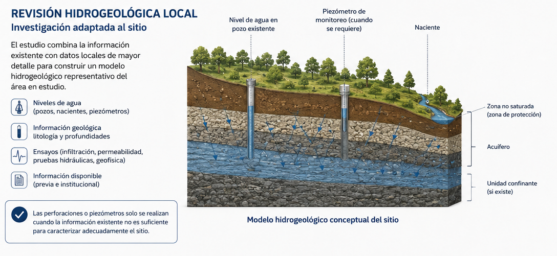
Geo Costa Rica integrates the collected information into a local conceptual hydrogeological model.
The model connects geology, aquifer position, groundwater levels, the unsaturated zone, recharge, discharge and flow direction to explain how the system behaves in the assessed area.
Based on that interpretation, hydrogeological vulnerability can then be evaluated using the methodology and technical criteria appropriate to the case.
The outcome is not decided before the investigation
An objective technical reassessment must allow the evidence to determine the conclusion, even if it agrees with the existing classification.
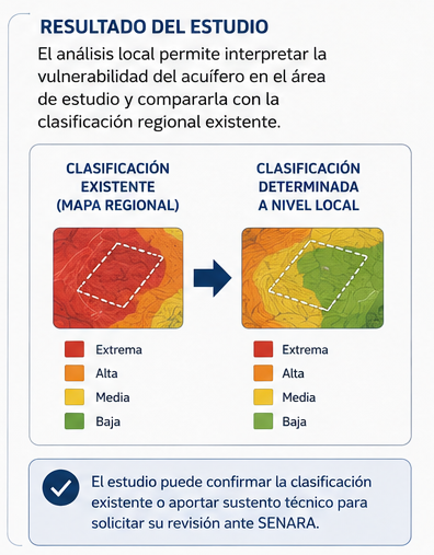
Confirm the existing classification
The investigation may show that local conditions are consistent with the vulnerability indicated by the available information.
Support a different interpretation with technical evidence
If local evidence demonstrates different conditions, the study can document and technically justify that interpretation for subsequent institutional assessment.
Geo Costa Rica does not promise to “lower” or “change” a vulnerability category. We provide the investigation needed to identify and substantiate the site's hydrogeological conditions.
How does this relate to SENARA's Detailed Technical Opinion?
Vulnerability reassessment is not a third official category of technical opinion. It is a specialized application of local hydrogeological investigation.
Vulnerability Reassessment
Geo Costa Rica investigates local hydrogeological conditions, develops the conceptual model and technically assesses the vulnerability of the site.
SENARA Detailed Technical Opinion
When submitted under this procedure, SENARA reviews the supporting hydrogeological study and issues the corresponding institutional technical opinion.
SENARA Detailed Technical OpinionWhat does Geo Costa Rica do, and what does SENARA do?
The technical study and the institutional decision are distinct stages.
Investigates and provides technical substantiation
- Reviews mapping and background information.
- Defines the technical scope of the investigation.
- Performs fieldwork when applicable.
- Integrates geology, hydrogeology and mapping.
- Develops the conceptual hydrogeological model.
- Assesses vulnerability at a local scale.
- Prepares the report and supporting technical evidence.
- Can manage submission to SENARA.
Reviews and issues the institutional opinion
- Receives the application when applicable.
- Reviews the methodology and evidence presented.
- Assesses the hydrogeological interpretation.
- May request clarifications or additional information.
- Determines the applicable institutional technical opinion.
Preparing a technically substantiated study does not oblige SENARA to accept the proposed interpretation. The institutional assessment is SENARA's exclusive responsibility.
How do we approach a vulnerability reassessment?
First, we establish whether further analysis is technically justified. We then design the investigation required to resolve the site's uncertainties.
Questions about hydrogeological vulnerability and SENARA
These are common questions when a vulnerability classification affects a property or development project.
Can a property's hydrogeological vulnerability classification be changed?
A local hydrogeological investigation can assess whether the existing classification adequately represents the site. It may confirm the current category or technically support a different interpretation.
Can Geo Costa Rica change a SENARA map?
No. Geo Costa Rica conducts the investigation and prepares the technical evidence. When submitted to SENARA, institutional review of the information is SENARA's responsibility.
What if the map does not reflect the conditions of my property?
We can assess whether there is a technical basis for a more detailed local hydrogeological characterization and compare its findings with the existing classification.
Does the study guarantee a lower vulnerability classification?
No. Conclusions depend on the evidence. An objective study may identify lower, equivalent or even more restrictive conditions than anticipated.
Is drilling always required for the study?
No. The scope depends on existing information and the uncertainty to be resolved. Boreholes, piezometers or geophysical methods are used only when technically justified.
What methodology is used to assess vulnerability?
The methodology must be compatible with the local hydrogeological model and the technical criteria applicable to the case. Classification should not be separated from how the aquifer functions.
Is reassessment a different procedure from the Detailed Technical Opinion?
It is not a third official type of technical opinion. It is a specific application of local hydrogeological investigation that may support a SENARA Detailed Technical Opinion.
What should I send Geo Costa Rica to review my case?
Ideally, provide the property's location, cadastral survey plan, the classification or map affecting the site, project information and any institutional requirements received.
Related procedures and studies
Vulnerability reassessment forms part of a broader hydrogeological context and may draw on different studies depending on the site.
SENARA Detailed Technical Opinion
The procedure under which SENARA reviews a local hydrogeological study submitted by the applicant.
SENARA General Technical Opinion
An inquiry based primarily on available hydrogeological information and project characteristics.
Hydrogeological Study
Characterization of geological conditions, aquifers and groundwater flow needed to understand how the site functions.
Is the existing classification affecting your property or project?
We can review the maps, background information and known site conditions to establish whether a more detailed hydrogeological reassessment is technically justified.
Send us the property's location, available cadastral survey plan, project information and any institutional documents or requirements related to groundwater vulnerability.