



Aquifer Vulnerability Assessment
At Geo Costa Rica, we conduct aquifer vulnerability assessments to determine how susceptible groundwater is to potential contamination based on the aquifer's natural characteristics, overlying materials, and depth to groundwater.
Assessing an aquifer's intrinsic susceptibility to contamination
Aquifer vulnerability describes how readily a contaminant load could reach groundwater, considering the system's natural protective conditions rather than whether contamination is currently present.
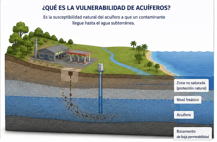
How vulnerable is this aquifer to incoming contaminants?
This assessment addresses that question by examining the geology, aquifer characteristics, depth to the water table, and overlying materials that provide natural protection.
It is important to distinguish vulnerability from related concepts. Vulnerability describes an intrinsic characteristic of the hydrogeological system; a hazard refers to a potentially contaminating activity or source; and risk results from the interaction between the two.
- An aquifer may be highly vulnerable without currently being contaminated.
- Vulnerability is not determined by land use alone.
- The assessment provides a technical basis for groundwater protection, land-use planning, and environmental evaluation.
The method is selected according to the aquifer and the required level of detail
In Costa Rica, aquifer vulnerability may be assessed using methods such as GOD and, where appropriate, DRASTIC, SINTACS, or EPIK, depending on the hydrogeological setting and the study objectives.
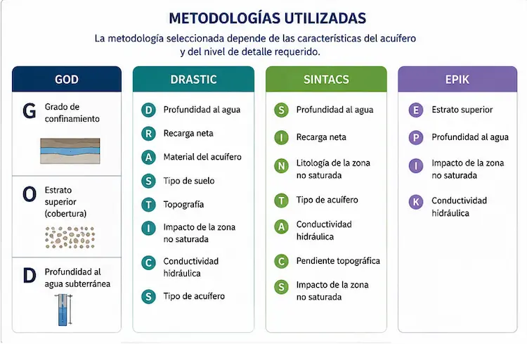
GOD is one method; this page describes the broader assessment
GOD is frequently used as a basis for vulnerability assessment, particularly when evaluating groundwater confinement, overlying strata, and depth to groundwater. However, not every aquifer or project requires the same approach.
Hydrogeological variables
- Confinement or aquifer conditions.
- Overlying materials and natural protection.
- Depth to groundwater.
- Recharge, lithology, or topography, where relevant.
Scale and method
- Level of detail required by the project.
- Availability of existing information.
- Need for supplementary field investigations.
- The most technically appropriate method for the specific case.
The assessment combines existing information, local investigation, and technical interpretation
A thorough vulnerability assessment involves more than applying a formula. The aquifer must first be understood, followed by an interpretation of how its natural conditions affect groundwater protection.
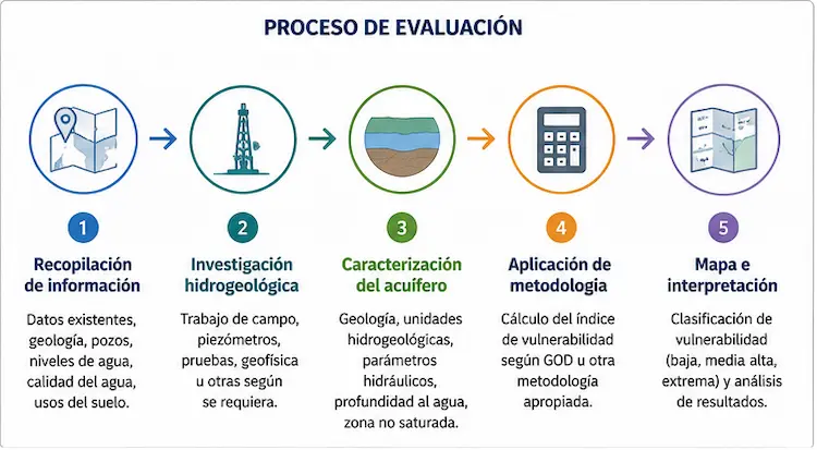
How Geo Costa Rica prepares the report
The report may include vulnerability classification and mapping
Depending on the scale and objectives, results may be presented as vulnerability classes and spatial interpretations of the aquifer, supporting land management, environmental studies, and groundwater protection.
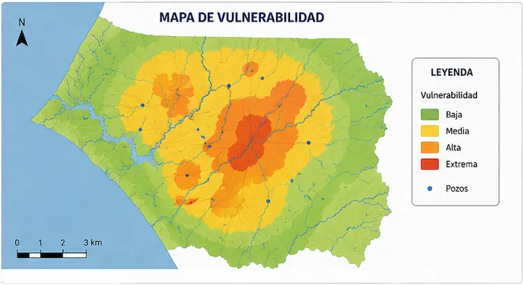
A technical basis for interpreting the aquifer's natural protection
- Hydrogeological characterization of the system being assessed.
- Vulnerability classification according to the selected method.
- A vulnerability map when spatial mapping is within the study scope.
- Interpretation of what the findings mean for the site or project.
- Technical input for environmental assessment, aquifer protection, and land-use planning.
Depending on the scope, vulnerability may be classified as low, moderate, high, or extreme. The final interpretation must reflect the project's context and should not rely solely on the colors displayed on a map.
When is an Aquifer Vulnerability Assessment needed?
This report can be useful when the aquifer's natural characteristics must be understood to support technical, environmental, or planning decisions.
Projects or properties overlying sensitive aquifers
When it is necessary to establish whether the aquifer's intrinsic hydrogeological characteristics make it more or less susceptible to contamination.
Technical or regulatory processes
The assessment may form part of environmental studies, water resource investigations, or evaluations requiring evidence of groundwater vulnerability.
Defining restrictions or protective measures
Vulnerability findings can help inform management measures, compatible land uses, and groundwater protection criteria.
Land-use planning and spatial analysis
Vulnerability maps can support planning decisions by showing relationships between potentially contaminating activities and more sensitive areas.
Vulnerability is one part of the assessment, not the whole picture
Depending on the case, this report may be complemented by contaminant transport assessments, protection zone delineation, geophysical surveys, or broader hydrogeological studies. It also relates to aquifer protection services and more detailed vulnerability reassessments where official vulnerability maps already exist.
Common questions about aquifer vulnerability
What does high aquifer vulnerability mean?
It means the aquifer's natural conditions allow contaminants to reach groundwater relatively more easily than in less vulnerable aquifers.
Does high vulnerability mean the water is already contaminated?
No. Vulnerability refers to natural susceptibility. Whether groundwater is currently contaminated must be evaluated separately.
Is GOD always used?
GOD is widely used, but it is not the only method. Selection depends on aquifer type, available data, and the technical purpose of the assessment.
Can this assessment support environmental evaluation and groundwater protection?
Yes. It can provide important input for environmental analyses, land-use decisions, aquifer protection, and related hydrogeological studies.
Request an Aquifer Vulnerability Assessment
Geo Costa Rica prepares technical vulnerability reports to characterize groundwater susceptibility, apply an appropriate assessment method, and provide findings that support groundwater protection, environmental evaluation, and water resource management.