



Slope Stability and Mass Movement Assessment
We analyze slope configuration, geological materials, water conditions, and geomorphological evidence to understand mass movement processes, identify relevant areas, and relate site conditions to the areas planned for project development.
A slope is a system where terrain, materials, water, and processes interact
Slope steepness is only part of the picture. To interpret a slope, we need to understand its geometry, the materials that form it, drainage conditions, and evidence of processes that have modified the terrain.
Landforms help reconstruct how displacement occurred
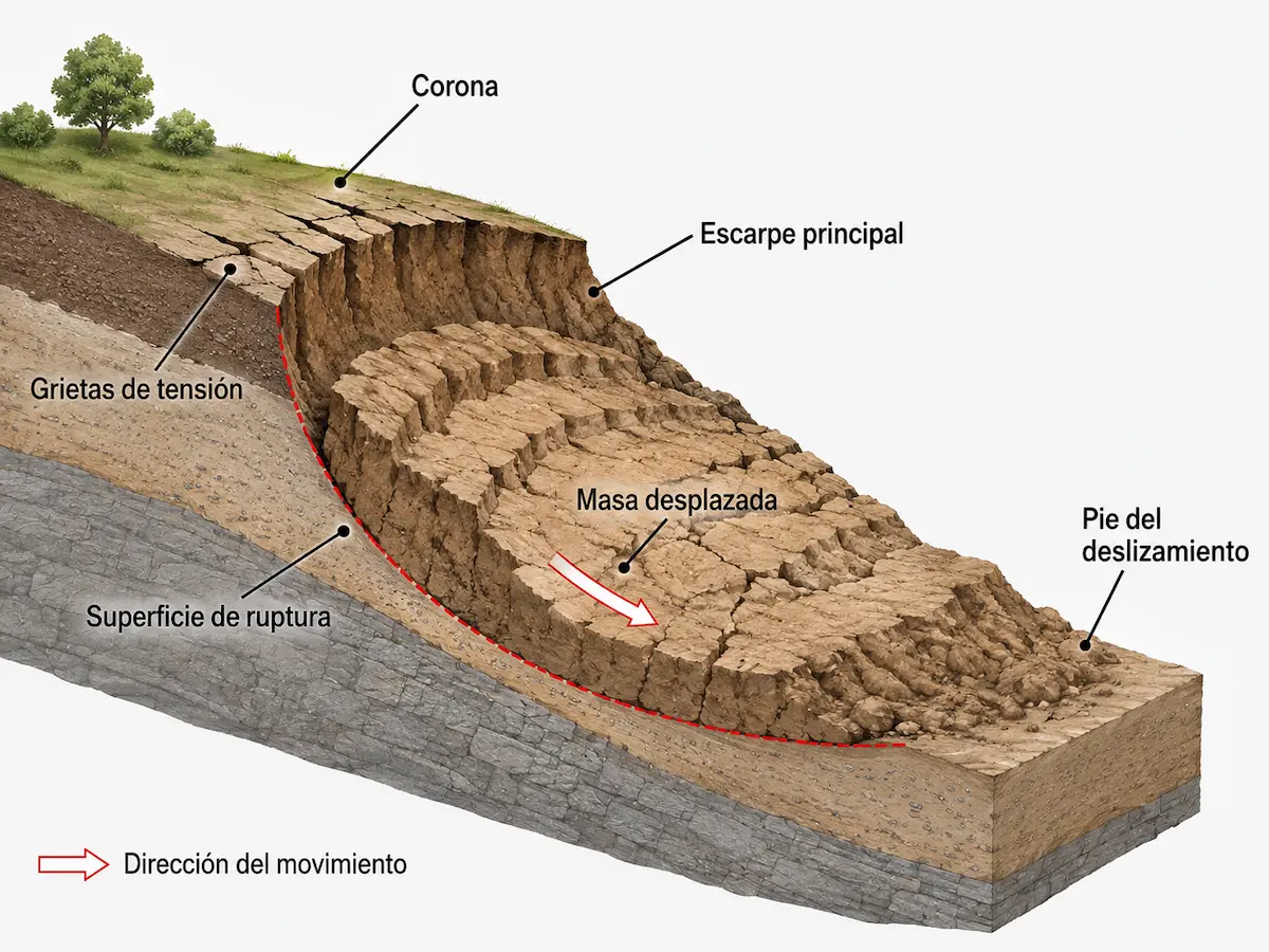
A mass movement may retain recognizable features: a crown, tension cracks, a scarp, a rupture surface, displaced material, and accumulation at the toe.
Recognizing these features helps interpret the likely extent of the process and understand how the slope has changed.
- Crown and main scarp.
- Cracks or deformation in the upper section.
- Probable sliding surface.
- Displaced mass and accumulation areas.
Slope shape influences processes
Gradient, height, changes in inclination, concavities, and scarps help explain slope configuration.
Different ground materials behave differently
Soils, deposits, weathered rock, and other units may respond differently to slope gradients and water.
Drainage modifies slopes
Runoff, infiltration, springs, and concentrated water flows can influence certain geomorphological processes.
The terrain preserves signs
Scarps, cracks, deformation, and deposits can provide information about current or past processes.
A steep slope does not automatically mean that a mass movement is present. Slope steepness must be interpreted together with geometry, materials, water, and evidence observed on site.
We analyze the conditions that help explain how the terrain behaves
We integrate topography, geomorphology, geology, drainage, land alterations, and field evidence to identify areas with distinct characteristics within the same property.
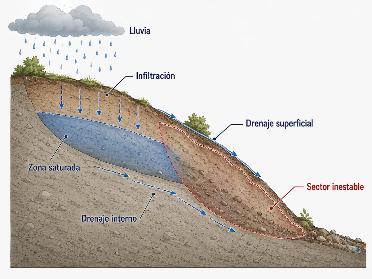
Slope behavior depends on more than gradient
Surface water and groundwater are part of the interpretation. Rainfall may generate runoff, infiltrate certain materials, or accumulate along contacts and less permeable zones.
These conditions must be related to geometry, geological materials, and observed evidence, without assuming that water alone caused a particular process.
Cuts, fills, and changes to the terrain
Development activities can change original slope geometry and drainage, creating conditions different from those that existed naturally.
Signs consistent with ground deformation
We document cracks, scarps, irregularities, deformation, deposits, and other signs whose distribution may help interpret mass movements.
The site must be interpreted within its surroundings
We review historical information, CNE records, maps, geology, and other sources before comparing them with the conditions observed directly on the property.
No single variable determines slope behavior. Interpretation comes from connecting terrain, geological materials, water, land alterations, and evidence within a single system.
We analyze landforms and verify evidence directly in the field
We combine existing information, terrain models, spatial analysis, geology, and field reconnaissance to develop a coherent interpretation of the slope.
We develop a preliminary understanding
We review mapping, known hazards, terrain models, geology, photographs, and records to identify areas requiring closer attention.
We verify evidence in the field
We examine geometry, materials, drainage, cuts, cracks, scarps, deposits, and other relevant signs directly on the ground.
We relate slope conditions to the project
We connect the evidence to topography, geology, and planned development areas to identify relevant sectors and uncertainties requiring resolution.
Surface features may reveal a history of past movements
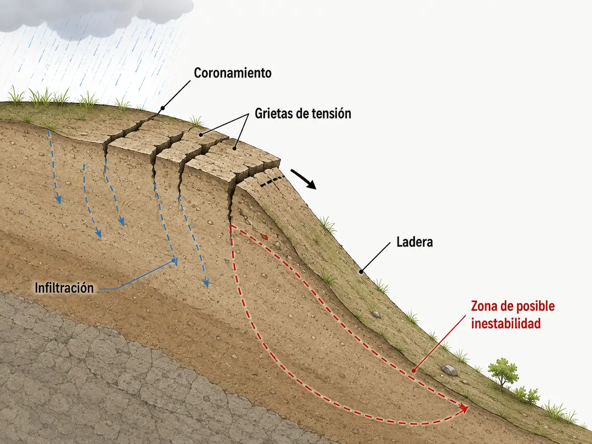
Cracks, crowns, scarps, and deformation may indicate that a slope has undergone displacement, but a single observation rarely explains the entire process.
We look for relationships between multiple features to distinguish a local anomaly from a consistent geomorphological pattern.
- Identify patterns in the terrain.
- Verify evidence directly in the field.
- Relate materials, water, and geometry.
- Develop an interpretation of the process.
When we need to understand what lies below ground
Some conditions may require drilling, geophysical surveys, or other methods to characterize materials, thicknesses, or geometries not exposed at the surface.
When we need to quantify stability
If the question requires mechanical properties, factors of safety, or quantitative analyses, specific geotechnical investigations are needed.
When we need to observe changes over time
When a single observation cannot determine whether a condition is changing, monitoring over an appropriate period may be necessary.
A slope assessment identifies and interprets geomorphological conditions. It does not automatically replace a geotechnical design analysis. Where stability must be quantified, the appropriate complementary investigation is defined.
The results help identify where the most relevant slope conditions occur
We integrate geomorphology, geology, slopes, drainage, and evidence into a spatial interpretation that helps identify processes, distinct areas, limitations, and uncertainties at the site.
Distinguishing areas with different characteristics
A slope can be divided into units based on landform, gradient, materials, and evidence to better understand its variability.
Identifying relevant dynamics
Where the evidence supports it, we interpret mass movements, erosion, and other processes that help explain current conditions.
Representing site conditions spatially
Where appropriate, we map geomorphological units, evidence, and relevant areas in a format tailored to the project.
Relating the slope to planned interventions
We assess connections with building platforms, structures, access roads, cuts, fills, and other project components.
Distinguishing what is known from what requires investigation
We separate evidence-supported conclusions from matters requiring additional subsurface information or monitoring.
Identifying the next investigative step
Results help determine where further work would be most useful and what additional information the project actually needs.
Recognizing evidence of movement does not prove that it is currently active
A slope may retain signs of ancient or recent processes, or features subsequently modified by erosion, vegetation, or human activity.
Where the activity or evolution of a movement is critical, repeated observations, monitoring, or additional investigations may be needed.
Understanding the slope helps determine where to develop and where to investigate further
The assessment can support property evaluation, project planning, hazard analysis, and the selection of subsequent investigations.
Understanding a slope before purchasing or developing
An early assessment helps identify areas with particular geomorphological conditions before major property decisions are finalized.
Relating construction works to natural terrain
Interpretation makes it possible to compare areas and provide information for a preliminary assessment of where to locate project components.
Identifying alterations that require closer analysis
Where substantial changes to slope geometry are planned, we identify areas where further investigation is advisable before construction begins.
Examining previously identified conditions
Where maps or records indicate slope processes, the study examines how those processes are expressed within the property.
Guiding additional investigations
Surface interpretation helps determine where drilling, geophysical surveys, or other techniques could provide useful additional information.
Identifying conditions that may require monitoring
Where changes in a particular feature matter for the project, a specific observation or measurement program can be developed.
Specialized Natural Hazard Studies
These studies help relate slope processes to other hazards potentially relevant to the property and project.
Explore These StudiesSite Geological Study
This study examines geological materials, units, structures, and processes that can help explain the conditions observed on the slope.
Explore This StudySubsurface Investigation
This complements surface information when we need to know material types, thicknesses, or conditions that cannot be determined directly from the surface.
Explore This ServiceFirst understand the slope; then determine whether its stability needs to be quantified
Geomorphological interpretation helps identify processes, relevant areas, and questions requiring more detailed answers.
If the project subsequently requires mechanical properties, factors of safety, or quantitative stability analysis, an appropriate specialized investigation can be undertaken.
Not every property with slopes automatically needs a complete geotechnical investigation. The preliminary assessment helps determine whether a specific question justifies moving toward more detailed methods.
Frequently Asked Questions About Slopes and Mass Movements
A steep slope, a sign of deformation, or a previous hazard record does not automatically imply a stability problem. Each condition must be interpreted within the specific context of the site.
Does a steep slope mean there is a landslide risk?
Not necessarily. Slope gradient is important, but must be evaluated alongside geometry, geological materials, water conditions, land alterations, and evidence of existing processes.
What signs may indicate a mass movement?
Cracks, scarps, deformation, depressions, material accumulation, changes in drainage, and other irregularities can be indicators that must be interpreted together.
Does an old landslide still matter?
It may. An older movement can retain geometries and materials relevant to a current project, although assessing whether it is active requires additional evidence.
Does a hazard map replace field investigations?
No. Regional mapping provides background and context, but conditions must be verified at the scale of the property and the areas where the project is planned.
Is a slope assessment the same as a slope stability analysis?
No. A slope assessment interprets geomorphological processes, evidence, and site conditions. A geotechnical stability analysis uses mechanical properties and quantitative methods to evaluate slope stability.
When are drilling or geophysical surveys necessary?
When surface information is insufficient to determine relevant subsurface materials, thicknesses, geometries, or conditions. Investigations should target the uncertainties that need resolving.
How is it determined whether a movement is active?
Some evidence can be interpreted during a visit, but demonstrating change or displacement may require comparisons over time, measurements, instrumentation, or monitoring.
Can water affect slope stability?
Yes. Infiltration, saturation, runoff, springs, and drainage can modify ground conditions, but must be evaluated alongside geometry, materials, and other evidence.
Does your property have steep slopes or evidence of mass movements?
We can review project location, known hazards, terrain configuration, and proposed interventions to define the appropriate scope of assessment.
The goal is to understand site conditions first, then determine whether additional subsurface investigations, monitoring, or geotechnical analyses are genuinely needed.