



Faulting and Neotectonic Assessment
We investigate geological structures, lineaments and evidence of deformation to determine what can reliably be established at site scale, assess possible recent activity and evaluate their relationship to the proposed project.
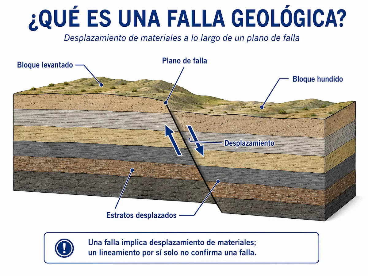
A geological fault involves displacement of materials
The assessment distinguishes verifiable geological structures from features that merely suggest a possible structural relationship. Interpretation must be based on evidence, not simply on the presence of a line on a map.
Displacement is the defining feature
A fault is a discontinuity along which geological materials have undergone relative displacement. This movement may be recognized through relationships among strata, contacts, structures and other evidence.
Therefore, a topographic anomaly or linear feature alone is not sufficient evidence to establish the existence of a fault.
- Fault plane or deformation zone.
- Displacement of geological units or contacts.
- Consistent structural relationships.
- Verifiable geological evidence.
The purpose of the assessment is not to prove that a fault exists at all costs.The aim is to determine what evidence exists, what interpretation it supports and what uncertainties remain.
A lineament guides investigation but does not by itself confirm a fault
Aligned landforms, straight valleys, abrupt slope changes or distinctive drainage patterns may suggest structural control and indicate areas deserving further investigation.
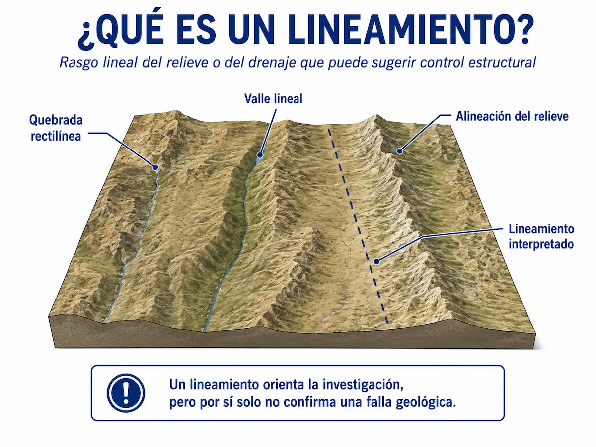
First we recognize patterns; then we investigate their causes
A lineament may be associated with a geological structure, but may also reflect erosion, lithology, drainage, land modification or other conditions.
We therefore combine geomorphological expression with mapping, geology, aerial photographs, terrain models and direct field observations.
A regional map line has spatial uncertainty
The mapped position of a structure must not automatically be transferred to a property with metre-level precision without verifying its location and meaning at an appropriate scale.
Landforms may preserve evidence
Scarps, facets, alignments, drainage offsets and other landforms may support a structural interpretation when multiple lines of evidence are consistent.
Surface cover can conceal structures
Soils, vegetation, recent deposits or human modifications may limit direct observation and justify complementary methods when the uncertainty is significant.
Lineament ≠ geological fault.A lineament indicates where to investigate; establishing a fault requires additional evidence.
The depth of investigation depends on the evidence and uncertainty
We start with existing information and geological-geomorphological reconnaissance. If the question cannot be answered adequately, we determine which additional investigation could provide the missing evidence.
Regional and local context
We review geological maps, known structures, terrain, drainage, photographs, previous studies and other available information to develop an initial hypothesis.
Field verification
We look for outcrops, contacts, fractures, displacement, geomorphological expressions and other evidence to test the initial interpretation.
Resolving uncertainty
When surface evidence is insufficient, additional investigation may be designed to address the specific unresolved question.
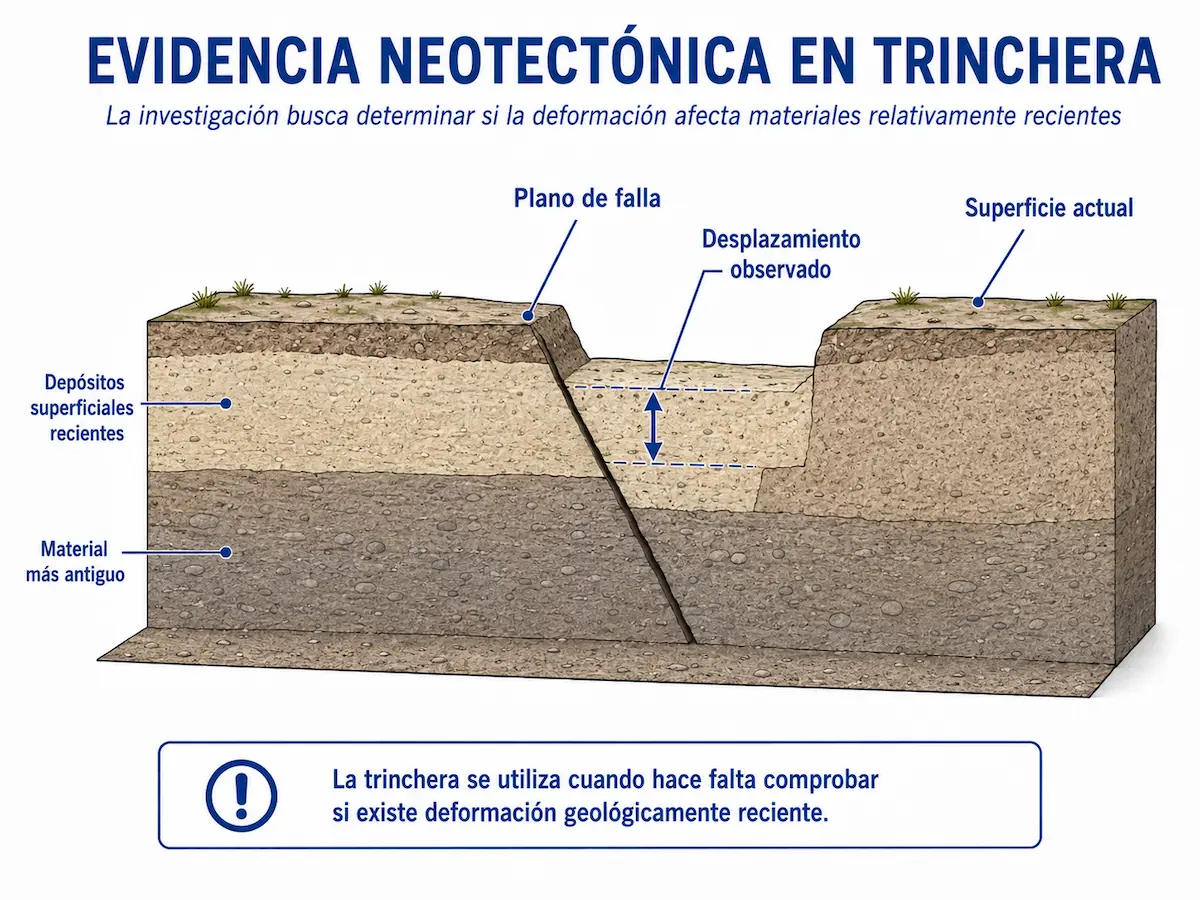
Neotectonics investigates evidence of geologically recent deformation
Confirming a fault does not automatically demonstrate that the structure has been active recently.
When this distinction matters to the project, it may be necessary to investigate whether deformation affects relatively young deposits or surfaces and reconstruct the sequence of events.
- Relative ages of units and surfaces.
- Relationship between the structure and recent deposits.
- Continuity of deformation.
- Confidence in the interpretation.
Investigating discontinuities beneath the surface
Geophysical methods may provide information about subsurface contrasts or geometry when a structure is insufficiently exposed for direct observation.
Directly exposing the sequence of materials
When warranted, excavation can reveal stratigraphic relationships, deformation and displacement that cannot be observed at the surface.
Use only methods that provide useful information
Methods are selected according to the existing evidence, the uncertainty to resolve and the importance of the conclusion for the project.
Not every neotectonic investigation automatically requires trenches, geophysics or excavation.We first determine what information is already available and which question actually requires additional investigation.
Separating observations, interpretations and levels of confidence
The report organizes the available evidence to determine which structures can be recognized, their likely locations, what supports the interpretation and what remains uncertain.
What can be observed directly
Outcrops, fractures, contacts, displacement, landforms and other relationships documented during the investigation.
Which model best explains the observations
We integrate different lines of evidence to assess whether a geological structure exists and its possible geometry and continuity within the investigated area.
How well the structure is understood
We distinguish conclusions supported by direct evidence from interpretations that remain uncertain because of cover, scale or insufficient exposure.
Locating the structure at a useful scale
When the information allows, we delineate the location or probable zone of the structure relative to the property and proposed project areas.
Assessing evidence of recent deformation
Neotectonic interpretation considers whether there are relationships supporting geologically recent activity or whether that remains unproven.
Relating the structure to proposed development
We analyze spatial relationships between identified structures and buildings, access roads, platforms or other project components.
Lineament, fault and active fault are not interchangeable
The assessment helps determine what a structure means for the site and project
A mapped fault, a lineament or structural evidence may require different levels of investigation depending on its position, confidence and relationship to areas of development.
Verifying a structure near a property
Moves beyond a regional map reference toward a more detailed interpretation of what can actually be recognized on or near a property.
Relating the structure to proposed works
We assess whether a structure's position or zone of uncertainty overlaps buildings, platforms, access routes or other relevant components.
Examining existing geological information
When maps, reports or previous studies indicate a structure, we assess what evidence actually exists at project scale.
Identifying where further investigation is needed
The assessment establishes when available evidence already answers the question and when higher-resolution methods would be useful.
Assessing evidence of recent activity
When the activity of a structure is relevant, its relationship to geologically recent deposits and surfaces may be investigated.
Guiding the next level of investigation
Results help determine whether geophysics, excavation, subsurface investigation or other complementary studies are necessary.
Site Geological Study
Characterizes geological units, materials, structures and processes within the site and its immediate surroundings.
Explore this studySubsurface Investigation
Provides additional information when relevant conditions cannot be directly observed from the surface.
Explore this serviceGeophysical Surveys
These can complement interpretation when investigating discontinuities, contrasts or geometries concealed below ground.
Explore geophysicsInterpret the evidence first; then choose the tools the project needs
The investigation does not assume that trenches, boreholes or geophysics are always required.
Each method should be applied when it can resolve a specific uncertainty and provide information that genuinely improves project understanding or decisions.
Frequently asked questions about faulting and neotectonics
A line on a map, a linear landform or even a known geological fault does not automatically mean that a property is directly affected.
Does a fault shown on a map mean it crosses my property at that exact location?
Not necessarily. Its mapped position depends on scale, available information and confidence. Where the relationship to a property matters, it must be verified at an appropriate scale.
Is a lineament a geological fault?
No. A lineament is a linear feature observed or interpreted in topography, drainage or imagery. It may suggest structural control, but additional evidence is needed to establish that it corresponds to a fault.
Is a geological fault necessarily active?
No. Identifying a fault establishes that displacement occurred, but determining whether it has been active in geologically recent times requires additional evidence about the age of deformation.
What is a neotectonic study?
It is an investigation of evidence of geologically recent deformation and the relationships between a structure, young geological materials and the site's recent evolution.
Is it always necessary to excavate trenches?
No. A trench is an investigation tool used when stratigraphic relationships and deformation need to be observed directly and cannot be adequately resolved using available surface information.
Can geophysics detect a fault?
It can provide information about discontinuities, changes in physical properties and subsurface geometry, but the results must be integrated with the geological model and other available evidence.
Are faulting and seismic hazard the same thing?
No. Fault investigations examine geological structures, their locations and possible activity. Seismic hazard also addresses ground motion associated with seismic sources and answers a different question.
What happens if a relevant structure is confirmed near the project?
Next steps depend on its location, characteristics, confidence, possible activity and relationship to proposed works. The study helps identify which additional information or technical decisions may be needed.
Lineament → fault → recent activityare distinct levels of interpretation. The assessment establishes how far the available evidence can genuinely support conclusions.
Is there a fault or lineament near your property?
We can review the site location, geological maps, relief and available background information to assess what evidence exists and what level of investigation may be needed.
Our aim is to answer the geological question first, expanding the investigation only where uncertainty calls for geophysics, excavation, subsurface investigation or other specific methods.