



Saltwater Intrusion Assessment
At Geo Costa Rica, we prepare saltwater intrusion risk assessments to determine whether hydrogeological conditions, well depth and pumping operations could promote saltwater influence on a coastal aquifer or well.
Assessing the balance between freshwater and saltwater
In coastal aquifers, groundwater maintains a hydraulic relationship with seawater. Pumping can disturb this balance, potentially causing the saline transition zone to move or rise toward a well.
Could this well's conditions promote saltwater intrusion?
The answer does not depend on distance from the sea alone. We must consider the well's position within the coastal system, its depth, groundwater levels, geology, and planned or existing pumping operations.
This study combines these variables to assess whether groundwater extraction could alter aquifer hydraulics and increase the risk of well salinization.
Pumping can change the relationship between an aquifer and saltwater
Fresh groundwater generally flows from inland areas toward the coast. When pumping causes sufficient drawdown, it may locally alter hydraulic gradients and promote saltwater movement toward the well.
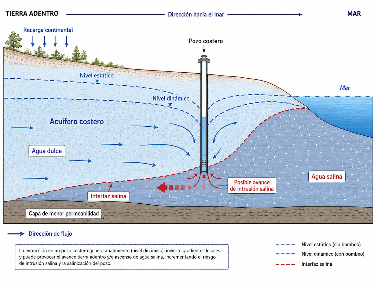
The position of the interface may respond to changes in the system
The relationship between freshwater and saltwater is not static. It may change with groundwater recharge, aquifer levels or pumping conditions.
Risk depends on well construction, aquifer conditions and pumping
The study brings together different types of information to jointly assess well location, hydraulic conditions and available water-quality indicators.
How the well is built and operated
- Location within the coastal hydrogeological system.
- Ground elevation and position relative to sea level.
- Total well depth and screened or intake intervals.
- Static and dynamic groundwater levels.
- Pumping rate and operating regime.
Conditions surrounding the well
- Geology and aquifer configuration.
- General direction of groundwater flow.
- Recharge and groundwater-level behavior.
- Electrical conductivity, where measurements are available.
- Chlorides and other available hydrochemical records.
Not every study requires the same field investigations
Depending on existing information and system complexity, pumping tests, groundwater-level monitoring, water-quality analyses, geophysical surveys or other methods may be used to strengthen the interpretation.
These methods contribute evidence but do not replace an integrated hydrogeological assessment.
A risk assessment based on the well's actual conditions
The report integrates available evidence to determine whether hydrogeological and pumping conditions may promote saltwater influence on the well.
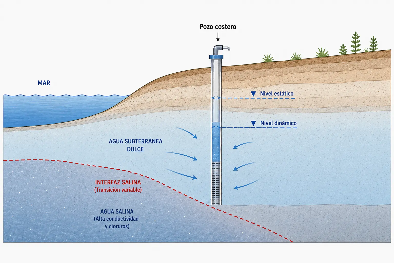
An interpretation that supports well-management decisions
The findings need not be reduced to “intrusion” or “no intrusion”
In some cases, the technical conclusion may indicate that groundwater levels, water quality or pumping conditions require monitoring to maintain extraction practices compatible with aquifer behavior.
When is a saltwater intrusion risk assessment useful?
This study is particularly useful when a well is part of a coastal hydrogeological system and conditions warrant assessment of potential saltwater influence.
The assessment may draw on other hydrogeological investigations
Common questions about saltwater intrusion risk
Does every well near the sea experience saltwater intrusion?
No. Risk depends on hydrogeological configuration, well location and depth, groundwater levels, pumping conditions and other site-specific factors.
Does elevated electrical conductivity prove saltwater intrusion?
Not necessarily. Conductivity and chloride are useful indicators, but they must be interpreted in light of hydrogeology and other evidence to identify the origin of observed salinity.
Can pumping rates increase the risk?
Yes. Significant drawdown can alter hydraulic gradients around a well. The effect depends on the aquifer, well depth and operating conditions.
Can this study be requested as part of an institutional procedure?
Yes. Some groundwater-related administrative procedures may require information about saltwater intrusion risk. The scope must reflect the specific case and applicable requirements.
Explore our permitting servicesAssess saltwater intrusion risk at your well
Geo Costa Rica prepares saltwater intrusion risk assessments for wells and projects in coastal aquifers, integrating hydrogeology, pumping conditions and water quality.