



Standard Penetration Test (SPT)
At Geo Costa Rica, we carry out Standard Penetration Tests (SPT) to investigate subsurface conditions, assess how penetration resistance varies with depth, and obtain useful information for soil studies and construction projects in Costa Rica.
A widely used method for subsurface investigation
The Standard Penetration Test, or SPT (Standard Penetration Test), is a geotechnical investigation method used to measure soil penetration resistance and recover disturbed samples during subsurface exploration.

How does ground resistance change with depth?
The SPT helps identify changes in subsurface materials and ground response as the investigation advances.
The test records the number of hammer blows required to drive a standard sampler into the ground. This measurement, generally known as the N, is interpreted alongside depth, observed stratigraphy, and recovered samples.
The SPT is an investigation tool. Its value depends on how the results are interpreted in the geotechnical context of the site and project.
How the Standard Penetration Test Is Performed
The test is conducted during subsurface exploration and combines drilling, sampler penetration, blow counts, and sample recovery.
A standardized procedure for collecting comparable data
In brief, the SPT involves driving a sampler into the ground using controlled hammer blows. In practice, a standard hammer weighing 63.5 kg is dropped through 76 cm while ground resistance is recorded during penetration.
The recorded values are interpreted alongside the depth reached, material descriptions, and samples recovered during the investigation.
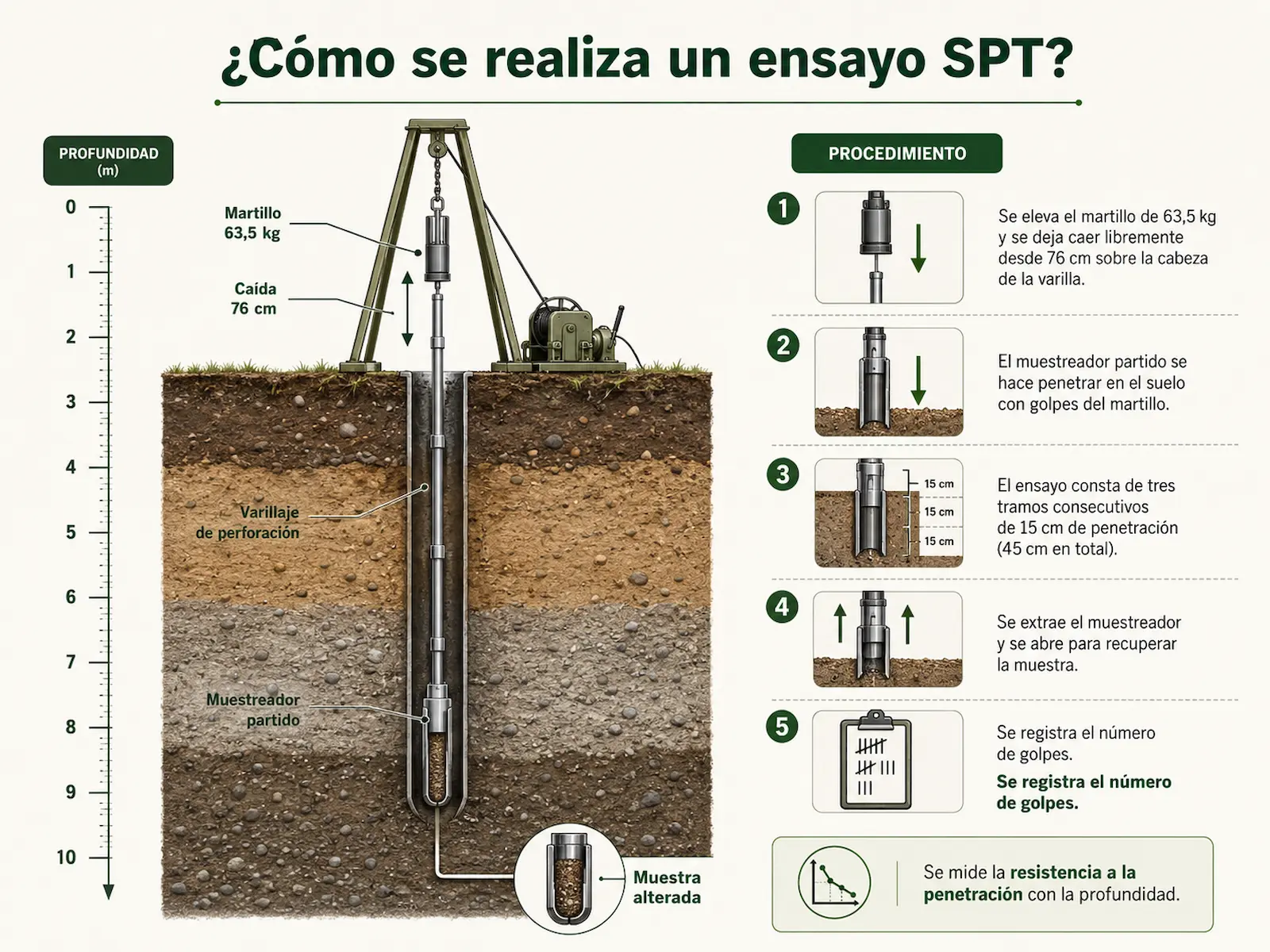
Drill
Advance the borehole to the depth selected for testing.
Test
Drive the sampler into the ground using controlled blows.
Record
Record the blow count and test depth.
Recover a Sample
Recover a disturbed sample to help identify the material.
What Information Can an SPT Provide?
The value of the SPT lies not only in counting blows but in integrating those data with depth, stratigraphy, and descriptions of the materials encountered.
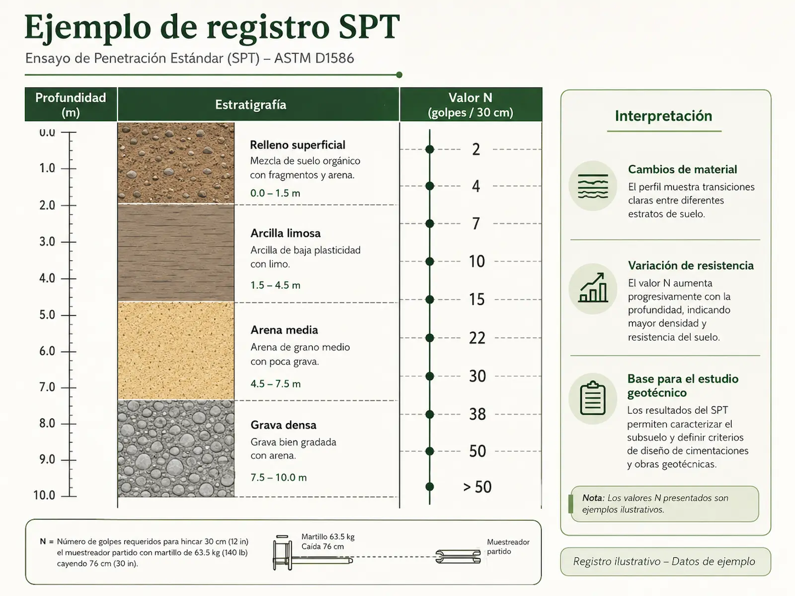
The SPT helps establish a subsurface profile
Based on field measurements and recovered samples, the test provides information for characterizing the ground and supporting geotechnical interpretation of the site.
The N-value should not be interpreted in isolation
SPT results must be assessed alongside depth, site conditions, material descriptions, and the project objectives. For this reason, the test forms part of a broader geotechnical investigation and does not, by itself, replace a Soil Study.
The SPT provides data; the Soil Study integrates the interpretation
At Geo Costa Rica, we use the SPT as part of geotechnical investigations designed to understand ground conditions and translate field information into useful technical criteria for a project.

A logical sequence of investigation and interpretation
SPT
We collect field data and samples.
Data
We organize measurements, depths, and descriptions.
Geotechnical Model
We interpret the subsurface configuration.
Project
We apply the findings in the technical study.
When the main objective is to understand the overall geotechnical conditions of a site, the SPT should be considered one component of the investigation undertaken for a Soil Study.
When Might an SPT Be Appropriate?
The SPT is especially useful when direct subsurface investigation is needed to characterize materials and identify changes in resistance with depth.
Not every site or project requires SPT testing
In some cases, DPL testing, geophysical methods, exploratory drilling, or a combination of methods may be more appropriate. The scope of the investigation should reflect the project’s actual requirements.
Common Questions About SPT Testing
What does the SPT N-value mean?
It is the measurement representing penetration resistance recorded during the test. Interpretation must consider the depth, material encountered, and geotechnical context of the site.
What samples does the SPT recover?
The test allows disturbed samples to be recovered, helping identify and describe subsurface materials during the investigation.
Are an SPT and a Soil Study the same thing?
No. The SPT is a test or investigation tool. A Soil Study is the technical report that integrates SPT results with other observations to interpret ground conditions.
How much does an SPT cost?
The cost depends on the number of boreholes, required depth, location, site access, and investigation scope. We can prepare a quotation after reviewing the project.
Request a Standard Penetration Test
At Geo Costa Rica, we carry out SPT investigations for geotechnical assessments and soil studies supporting construction projects in Costa Rica.