



Coastal Aquifers and Saltwater Intrusion
We assess groundwater behavior in coastal areas and the relationship between freshwater and saltwater to understand conditions that may affect wells, water intakes and projects that rely on groundwater resources.
At the coast, freshwater and saltwater are part of the same system
Coastal aquifers receive freshwater through inland recharge while also being influenced by their proximity to the sea. The distribution of both types of water depends on groundwater levels, geology, recharge and how the resource is used.
Freshwater flows in from inland areas
Rainwater that infiltrates and reaches the groundwater system replenishes the aquifer and helps maintain freshwater levels that support wells and other coastal water intakes.
Geology controls how water moves
Permeability, aquifer thickness, fracturing and the continuity of geological materials determine freshwater movement and how the system interacts with marine influence.
Saltwater can migrate into the system
When freshwater levels decline or aquifer hydraulic conditions change, marine influence may migrate toward areas where wells or groundwater abstractions are located.
Freshwater and saltwater are hydraulically connected
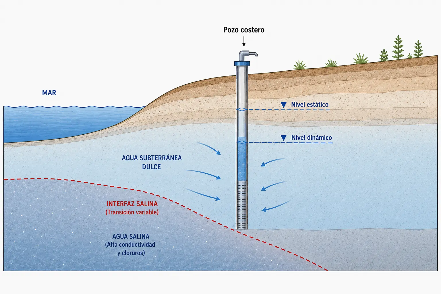
In certain coastal aquifers, freshwater from inland recharge moves toward the shoreline and encounters more saline water associated with the marine environment.
Differences in density can produce characteristic distributions of freshwater, brackish water and saltwater. The position and extent of these zones depend on the aquifer’s hydraulic and geological conditions.
This distribution is not a fixed boundary. Changes in recharge, groundwater levels and abstraction can gradually alter system conditions.
Pumping can change the position of saltwater
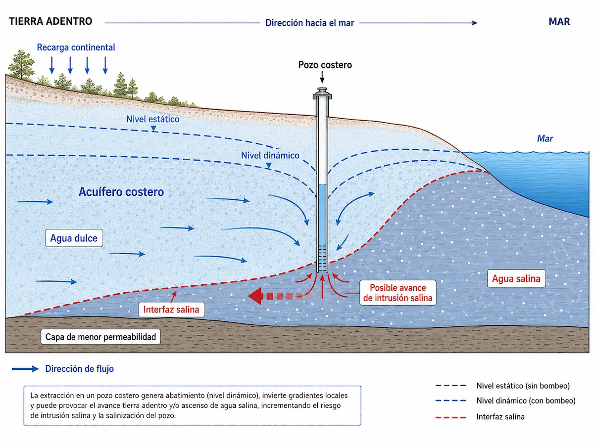
Pumping from a well causes groundwater levels to decline around the intake. In coastal aquifers, this response can disrupt the existing balance between freshwater and marine influence.
The response depends on the pumping rate, well depth and location, available recharge and the system’s hydrogeological characteristics. As a result, two wells near the coast may behave very differently.
Proximity to the sea does not automatically mean saltwater intrusion is occurring. Conditions must be interpreted within the hydrogeological system, considering groundwater levels, geology, recharge and the aquifer’s response to abstraction.
Conditions controlling the balance of a coastal aquifer
We integrate site hydrogeology with groundwater levels, water quality and abstraction conditions to understand how the system responds to marine influence.
Geology and aquifer continuity
We examine geological materials, permeability, fracturing, thickness and continuity to understand groundwater circulation and how marine influence may spread through the system.
Groundwater levels and elevation relative to sea level
In a coastal aquifer, knowing only the depth to water below ground surface is not enough. We also determine its elevation relative to sea level, which helps interpret aquifer hydraulic conditions, the gradient toward the coast and the relative position of freshwater and more saline water.
Salinity and conductivity
Electrical conductivity, dissolved solids and other salinity indicators help identify changes in water composition and possible evidence of saline influence in a well.
Well depth, elevation and location
We consider where wells are located, their depth, their elevation relative to sea level and which parts of the system they intercept, as these factors are important for interpreting their relationship with the coastal aquifer.
Pumping rates and abstraction pressure
We examine pumping rates at the project and nearby wells to assess how abstraction may affect groundwater levels and the balance between freshwater and more saline water.
Recharge and changes over time
Where sufficient records exist, we assess seasonal or historical changes in groundwater levels and water quality to identify trends related to dry periods, recharge, pumping or other changes in the system.
Pumping may encourage saltwater migration
In coastal aquifers hydraulically connected to the sea, groundwater abstraction can lower piezometric levels and alter the gradients that maintain the distribution of freshwater and saltwater.
Depending on aquifer conditions, these changes may favor lateral movement of saltwater inland or upconing of more saline water from deeper zones near the well.
Interpreting this behavior requires relating pumping rates, groundwater levels, well location and depth, geology and trends in salinity indicators.
Salinity must be interpreted in its hydrogeological context
An elevated conductivity or salinity measurement may be an important signal, but it cannot by itself explain the origin or dynamics of the phenomenon.
To interpret conditions properly, water quality must be considered alongside well depth, groundwater elevation relative to sea level, geology, distance from the coast and pumping conditions.
Saltwater intrusion is identified through a combination of evidence. Coastal location, groundwater elevation relative to sea level, water quality, geology and abstraction conditions must be assessed together to understand what is happening within the aquifer.
We combine groundwater levels, water quality and abstraction conditions
Our investigations combine hydrogeological records, well information, spatial analysis and field measurements to understand how a coastal aquifer functions and whether signs of saline influence are present.
We reconstruct the hydrogeological setting
We review geology, topography, existing wells, depths, groundwater levels, pumping rates, water-quality records and other information that helps establish how the coastal system works.
We relate the aquifer to the coast and groundwater use
We integrate groundwater-level distributions, well locations, recharge and pumping conditions to interpret flow direction and identify areas where marine influence may be relevant.
We measure and monitor when needed
When the project requires it, we supplement the assessment with groundwater-level, conductivity, salinity or other measurements to verify water conditions and observe changes over time.
A single measurement cannot describe the entire system
Higher electrical conductivity may be an important signal, but its interpretation depends on where the sample was taken, at what depth and under what pumping conditions.
Where repeated measurements are available, we can compare groundwater levels and water quality over time to identify trends and distinguish temporary fluctuations from more persistent changes in the aquifer.
Saltwater intrusion is investigated as a process, not a single snapshot. Relating groundwater levels, water quality, pumping and changes over time helps determine whether conditions remain stable or whether changes require closer attention.
Make more informed decisions in coastal areas
Understanding the balance between freshwater and saltwater helps assess new water intakes, changes in demand and signs of declining water quality before adverse conditions become established in the aquifer.
Assess a water intake before development
Near the coast, distance from the high-tide line, ground elevation, drilling depth and groundwater elevation relative to sea level should be assessed in their hydrogeological context before defining the abstraction scheme.
Investigate changes in water quality
Increases in conductivity or salinity, or noticeable changes in water quality, can be assessed alongside groundwater levels, pumping and aquifer conditions to identify possible causes.
Assess increased groundwater abstraction
When a project plans to increase water consumption, it is important to examine whether the aquifer can sustain the new pumping regime without causing declines that may favor greater saline influence.
Plan projects that require groundwater
Residential, tourism, commercial and productive projects can consider aquifer availability and sensitivity early in their planning of water supply.
Assess cumulative pressure on the aquifer
In areas with multiple wells, combined abstraction can alter groundwater levels. Well distribution and pumping rates help explain the pressure placed on the resource.
Establish monitoring before problems arise
Periodic monitoring of groundwater levels and water-quality parameters can help identify early changes and adjust groundwater use before a trend becomes a limitation for the project.
Early action is especially important in coastal aquifers
Once saline influence reaches a well, restoring previous conditions may require prolonged changes in system operation.
Monitoring groundwater levels and water quality is therefore advisable, particularly when demand rises, new wells are installed or previous changes in salinity have been recorded.
Managing a coastal aquifer does not begin when saltwater appears in a well. Assessing system response and monitoring changes helps anticipate conditions that could compromise the resource’s quality or availability.
Technical studies to understand coastal aquifer response
Depending on the available information and the project's questions, we can further investigate aquifer characteristics, recharge, pumping response or interactions between wells.
Hydrogeological Study
Integrates geology, groundwater levels, wells, flow direction and abstraction conditions to interpret how the aquifer functions and how it interacts with its coastal setting.
Explore this studyWater Balance Assessment
Estimates how precipitation, evapotranspiration, soils and infiltration contribute to potential aquifer recharge, helping interpret water balance in coastal environments.
Explore this studyPumping Test
Shows how groundwater levels respond to controlled abstraction and provides information about the hydraulic behavior of the well and aquifer under pumping conditions.
Explore this studyWell Radius of Influence
Analyzes the spatial extent of the hydraulic response to pumping and helps assess possible interactions between wells drawing from the same aquifer system.
Salinity is only one part of the issue, not the entire assessment
When water quality changes, it is also necessary to understand the system’s hydraulics, recharge and abstraction conditions.
The appropriate study depends on whether the goal is to characterize the aquifer, analyze recharge, observe pumping response or assess the interaction of multiple abstractions in the same coastal system.
The study must address the behavior we need to understand. In a coastal aquifer, water-quality interpretation is stronger when linked to recharge, hydraulic conditions, the abstraction regime and interactions between wells.
Do you need to assess a well or groundwater abstraction in a coastal area?
We can review project location, existing well records, groundwater levels and available water-quality and salinity information to identify which aspects of the aquifer system require further investigation.