")
")
Geophysical Methods
At Geo Costa Rica, we offer specialized geophysical studies for subsurface characterization, using non-invasive methods that support geotechnical and hydrogeological analysis of the land.

What are geophysical studies?
Geophysical studies allow us to understand subsurface characteristics without the need for excavations or drilling. These methods measure physical properties of the ground such as electrical resistivity, seismic wave propagation speed, or variations in the magnetic field.
They are key tools to complement hydrogeological, geotechnical, and environmental assessment studies, as they provide accurate information about the internal structure of the ground and possible underground anomalies.
Methods Used
Geoelectrical Methods
Geoelectrical methods are based on measuring the electrical resistivity of the subsurface. This method helps identify the presence of aquifers, geological structures, and detect underground contaminants. The most commonly used techniques include:
- Electrical resistivity: Used to obtain a profile of the ground and its different layers.
- Resistivity tomography: Used to obtain three-dimensional images of the underground structure.
Seismic Methods
Seismic methods are based on the propagation of seismic waves through the ground. These waves can be artificially generated and recorded by geophones. This type of study is useful for obtaining information about the depth of rock layers, identifying discontinuities, and evaluating ground stability. Techniques include:
- Refraction and reflection seismics: Used to obtain detailed information about subsurface layers.
- Passive seismic REMI: Evaluation of the elastic properties of the subsurface without the need for active seismic sources.
Magnetic and Electromagnetic Methods
Magnetic and electromagnetic methods are used to assess the geological characteristics of the subsurface by measuring magnetic fields and ground resistivity. These non-invasive techniques are essential for obtaining detailed subsurface information without drilling.
- Magnetometry: Used to identify and map variations in the Earth's magnetic field, which indicate the presence of specific geological structures.
- Electromagnetic methods: Used to measure subsurface resistivity through electromagnetic fields, helping identify aquifer bodies or contaminants.
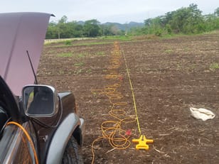
Real Examples of Geophysical Studies
Below are real images of fieldwork from geophysical studies conducted by Geo Costa Rica. These studies use specialized equipment to obtain information about the internal structure of the ground without drilling, including electrical resistivity, tomography, seismic, and electromagnetic methods. The photos show both the measurement process and interpreted results in graphical profiles.


Geo Costa Rica – Environmental Consultants
Processing, monitoring, and environmental consulting in hydrogeological studies, natural hazards, well drilling, water concessions, and Environmental Impact Assessments.
More Information?
For further information or quotes, feel free to contact us:
Desamparados, San José, Costa Rica
Phone: 2259-7340 | Mobile: 8721-6931
apadilla@geocostarica.com
Contact us here Environmental Viability (SETENA)
 Basic Engineering Study
 Basic Geology Study
 Archaeological Study
 Soil Studies
 DPL (Dynamic Probing Light)
 Geophysical Methods
 Exploratory Drilling
 Hydrogeology
 Natural Hazards
 Mining
 Well Drilling Permits (SENARA)
 Water Concession (Water Directorate)
 Water Availability
 Wastewater Treatment Location Permit
 Sanitary Sewer Exemption
 Infiltration Testing
 Water Flow Measurement
 Environmental Feasibility
 Procedures
 SETENA
 SENARA
 Geology and Mines Directorate
 Water Directorate